
Carte topographique Ringaskiddy
Carte interactive
Cliquez sur la carte pour afficher l’altitude.
À propos de cette carte
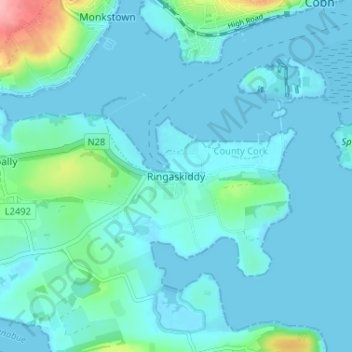
Nom : Carte topographique Ringaskiddy, altitude, relief.
Altitude moyenne : 13 m
Altitude minimum : -2 m
Altitude maximum : 107 m
Autres cartes topographiques
Cliquez sur une carte pour visualiser sa topographie, son altitude et son relief.
Meenane
Meenane, Watergrasshill, Municipal District of Cobh, County Cork, Munster, Ireland
Altitude moyenne : 173 m
Dough
Dough, Crookhaven ED, West Cork, County Cork, Munster, Ireland
Altitude moyenne : 35 m
Bandon
Bandon, The Municipal District of Bandon-Kinsale, County Cork, Munster, Ireland
Altitude moyenne : 59 m
Milford
Milford, The Municipal District of Kanturk-Mallow, County Cork, Munster, P56 PX32, Ireland
Altitude moyenne : 119 m
Rockfort
Rockfort, Brinny ED, The Municipal District of Bandon-Kinsale, County Cork, Munster, Ireland
Altitude moyenne : 53 m
Mallow
Mallow, The Municipal District of Kanturk-Mallow, County Cork, Munster, Ireland
Altitude moyenne : 77 m
Myrtleville Beach
Myrtleville Beach, Templebreedy, Municipal District of Carrigaline, County Cork, Munster, Ireland
Altitude moyenne : 32 m
Butter Bridge
Butter Bridge, Ballyfoyle ED, Municipal District of Carrigaline, County Cork, Munster, P17 K725, Ireland
Altitude moyenne : 70 m
Glounthaune
Glounthaune, Municipal District of Cobh, County Cork, Munster, T45 V201, Ireland
Altitude moyenne : 52 m
Killeens
Killeens, Coolmain ED, The Municipal District of Bandon-Kinsale, County Cork, Munster, Ireland
Altitude moyenne : 72 m
Rossmore
Rossmore, West Cork, County Cork, Munster, P85 TA48, Ireland
Altitude moyenne : 93 m
Municipal District of Cobh
Municipal District of Cobh, County Cork, Munster, Ireland
Altitude moyenne : 98 m
Matehy
Matehy, Municipal District of Macroom, County Cork, Munster, Ireland
Altitude moyenne : 107 m
Leamlara
Leamlara, Lisgoold, The Municipal District of East Cork, County Cork, Munster, T56 NH57, Ireland
Altitude moyenne : 145 m
Watergrasshill
Watergrasshill, Municipal District of Cobh, County Cork, Munster, Ireland
Altitude moyenne : 164 m
Dripsey
Dripsey, Municipal District of Macroom, County Cork, Munster, Ireland
Altitude moyenne : 85 m
Ballincurrig
Ballincurrig, Inch, The Municipal District of East Cork, County Cork, Munster, Ireland
Altitude moyenne : 41 m
Ballygarvan
Ballygarvan, Municipal District of Carrigaline, County Cork, Munster, T12 RR02, Ireland
Altitude moyenne : 70 m
Carrignavar
Carrignavar, Carrignavar ED, Municipal District of Cobh, County Cork, Munster, T34 ND26, Ireland
Altitude moyenne : 129 m
Courtbrack
Courtbrack, Matehy, Municipal District of Macroom, County Cork, Munster, Ireland
Altitude moyenne : 122 m
Kilcully
Ireland > County Cork > Cork
Kilcully, Rathcooney, Cork, County Cork, Munster, T23 HP30, Ireland
Altitude moyenne : 83 m
Coole East
Coole East, Rathcooney, Municipal District of Cobh, County Cork, Munster, Ireland
Altitude moyenne : 113 m
Macroom
Macroom, Municipal District of Macroom, County Cork, Munster, Ireland
Altitude moyenne : 110 m
Ballintemple
Ireland > County Cork > Cork
Ballintemple, Knockrea A, Cork, County Cork, Munster, Ireland
Altitude moyenne : 20 m
Cloyne
Cloyne, Cloyne ED, The Municipal District of East Cork, County Cork, Munster, P25 P792, Ireland
Altitude moyenne : 40 m
Waterfall
Waterfall, Inishkenny, Municipal District of Carrigaline, County Cork, Munster, T12 CYF2, Ireland
Altitude moyenne : 96 m
Castlemartyr
Castlemartyr, The Municipal District of East Cork, County Cork, Munster, Ireland
Altitude moyenne : 14 m
Kilpatrick
Kilpatrick, Municipal District of Carrigaline, County Cork, Munster, Ireland
Altitude moyenne : 89 m
Mallow
Ireland > County Cork > Mallow
Mallow, The Municipal District of Kanturk – Mallow, County Cork, Munster, P51 TW3W, Ireland
Altitude moyenne : 106 m
Knockraha
Knockraha, Municipal District of Cobh, County Cork, Munster, Ireland
Altitude moyenne : 114 m
Glanmire
Glanmire, County Cork, Munster, T45 X924, Ireland
Altitude moyenne : 58 m
Cork
Ireland > County Cork > Cork
Cork, County Cork, Munster, T12 T997, Ireland
Altitude moyenne : 94 m
Clonakilty Poor Law Union
Clonakilty Poor Law Union, County Cork, Munster, Ireland
Altitude moyenne : 58 m
Greencloyne
Greencloyne, Youghal Urban, The Municipal District of East Cork, County Cork, Munster, P36 PC43, Ireland
Altitude moyenne : 23 m
Kilcullen
Ireland > County Cork > Municipal District of Macroom
Kilcullen, Municipal District of Macroom, County Cork, Munster, Ireland
Altitude moyenne : 216 m
Skibbereen
Ireland > County Cork > Skibbereen
Skibbereen, West Cork, County Cork, Munster, P81 HH64, Ireland
Altitude moyenne : 48 m
Kilworth
Kilworth, The Municipal District of Fermoy, County Cork, Munster, P61 C996, Ireland
Altitude moyenne : 114 m
Glenbrook
Ireland > County Cork > Municipal District of Carrigaline
Glenbrook, Municipal District of Carrigaline, County Cork, Munster, T12 KT5N, Ireland
Altitude moyenne : 50 m
The Municipal District of Bandon – Kinsale
The Municipal District of Bandon – Kinsale, County Cork, Munster, Ireland
Altitude moyenne : 69 m
The Municipal District of Kanturk – Mallow
The Municipal District of Kanturk – Mallow, County Cork, Munster, Ireland
Altitude moyenne : 182 m
Ballinhassig
Ireland > County Cork > Municipal District of Carrigaline
Ballinhassig, Municipal District of Carrigaline, County Cork, Munster, T12 PN2X, Ireland
Altitude moyenne : 90 m
Buttevant
Buttevant, Buttevant ED, The Municipal District of Kanturk – Mallow, County Cork, Munster, Ireland
Altitude moyenne : 94 m
Ballygarvan
Ireland > County Cork > Cork
Ballygarvan, Ballygarvan ED, Cork, County Cork, Munster, T12 RR02, Ireland
Altitude moyenne : 104 m
The Municipal District of East Cork
The Municipal District of East Cork, County Cork, Munster, Ireland
Altitude moyenne : 59 m