
Carte topographique Fairmount
Carte interactive
Cliquez sur la carte pour afficher l’altitude.
À propos de cette carte
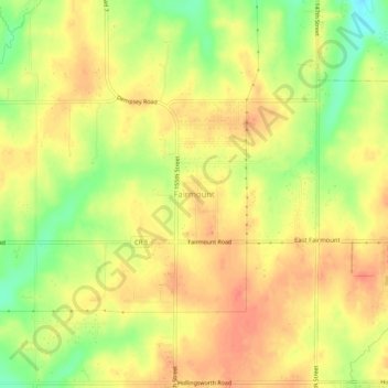
Nom : Carte topographique Fairmount, altitude, relief.
Lieu : Fairmount, Leavenworth County, Kansas, United States (39.17167 -94.95552 39.21167 -94.91552)
Altitude moyenne : 290 m
Altitude minimum : 259 m
Altitude maximum : 308 m
Autres cartes topographiques
Cliquez sur une carte pour visualiser sa topographie, son altitude et son relief.
Maywood
United States > Kansas > Leavenworth County > Leavenworth
Maywood, Leavenworth, Leavenworth County, Kansas, 64092, United States
Altitude moyenne : 246 m
Linwood
United States > Kansas > Leavenworth County
Linwood, Leavenworth County, Kansas, United States
Altitude moyenne : 248 m
Leavenworth
United States > Kansas > Leavenworth County > Leavenworth > Leavenworth
Leavenworth, Leavenworth County, Kansas, United States
Altitude moyenne : 268 m
Hoge
United States > Kansas > Leavenworth County
Hoge, Leavenworth County, Kansas, United States
Altitude moyenne : 276 m
Basehor
United States > Kansas > Leavenworth County
Basehor, Leavenworth County, Kansas, 66007, United States
Altitude moyenne : 286 m
Fort Leavenworth
United States > Kansas > Leavenworth County > Leavenworth > Leavenworth
Fort Leavenworth, Leavenworth, Leavenworth County, Kansas, 66027, United States
Altitude moyenne : 252 m
Lansing
United States > Kansas > Leavenworth County
Lansing, Leavenworth County, Kansas, 66043, United States
Altitude moyenne : 266 m
Leavenworth
United States > Kansas > Leavenworth County > Leavenworth
Leavenworth, Leavenworth County, Kansas, 66048, United States
Altitude moyenne : 277 m