
Carte topographique Lenggries
Carte interactive
Cliquez sur la carte pour afficher l’altitude.
À propos de cette carte
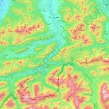
Nom : Carte topographique Lenggries, altitude, relief.
Altitude moyenne : 1’096 m
Altitude minimum : 615 m
Altitude maximum : 2’080 m
Lenggries sits on the Isar River before it transitions into the Alpine foothills. To the east are the Tegernsee Mountains, to the west lies the home mountain of Lenggries known as the Brauneck with an elevation of over 1,555 meters above sea level. The Brauneck is a well known ski area tied together by lifts. The town of Lenggries sits 700 meters above sea level.
Autres cartes topographiques
Cliquez sur une carte pour visualiser sa topographie, son altitude et son relief.
Beuerberg
Germany > Bavaria > Landkreis Bad Tölz-Wolfratshausen
Beuerberg, Eurasburg, Landkreis Bad Tölz-Wolfratshausen, Bavaria, 82547, Germany
Altitude moyenne : 618 m
Wegscheid
Germany > Bavaria > Landkreis Bad Tölz-Wolfratshausen > Lenggries
Wegscheid, Lenggries, Landkreis Bad Tölz-Wolfratshausen, Bavaria, 83661, Germany
Altitude moyenne : 750 m
Kochel am See
Germany > Bavaria > Landkreis Bad Tölz-Wolfratshausen
Kochel am See, Kochel am See (VGem), Landkreis Bad Tölz-Wolfratshausen, Bavaria, Germany
Altitude moyenne : 903 m
Geretsried
Germany > Bavaria > Landkreis Bad Tölz-Wolfratshausen > Geretsried
Geretsried, Landkreis Bad Tölz-Wolfratshausen, Bavaria, 82538, Germany
Altitude moyenne : 616 m
Egling
Germany > Bavaria > Landkreis Bad Tölz-Wolfratshausen > Egling
Egling, Landkreis Bad Tölz-Wolfratshausen, Bavaria, 82544, Germany
Altitude moyenne : 653 m
Benediktenwand
Germany > Bavaria > Landkreis Bad Tölz-Wolfratshausen > Benediktbeuern
Benediktenwand, Benediktbeuern, Benediktbeuern (VGem), Landkreis Bad Tölz-Wolfratshausen, Bavaria, Germany
Altitude moyenne : 1’363 m
Wolfratshausen
Germany > Bavaria > Landkreis Bad Tölz-Wolfratshausen > Wolfratshausen
Wolfratshausen, Landkreis Bad Tölz-Wolfratshausen, Bavaria, 82515, Germany
Altitude moyenne : 611 m
Schlehdorf
Germany > Bavaria > Landkreis Bad Tölz-Wolfratshausen
Schlehdorf, Kochel am See (VGem), Landkreis Bad Tölz-Wolfratshausen, Bavaria, 82444, Germany
Altitude moyenne : 802 m