
Carte topographique Kvilda
Carte interactive
Cliquez sur la carte pour afficher l’altitude.
Kvilda
Kvilda (German: Außergefild) is a village in Prachatice District, South Bohemian Region, Czech Republic. It lies in Šumava region, in the elevation of 1,065 m, making it the highest-located municipality in the country. It is also the coldest place in the Czech Republic with average annual temperature of 2 °C (36 °F). The average number of below-zero days per annum is 252.
À propos de cette carte
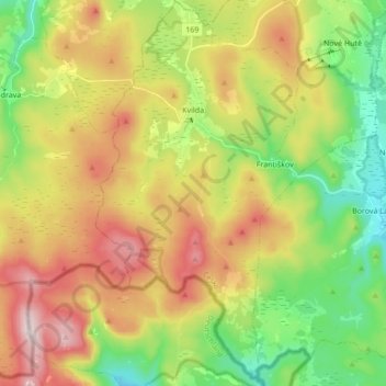
Nom : Carte topographique Kvilda, altitude, relief.
Altitude moyenne : 1’095 m
Altitude minimum : 882 m
Altitude maximum : 1’376 m