
Carte topographique Greer County
Carte interactive
Cliquez sur la carte pour afficher l’altitude.
À propos de cette carte
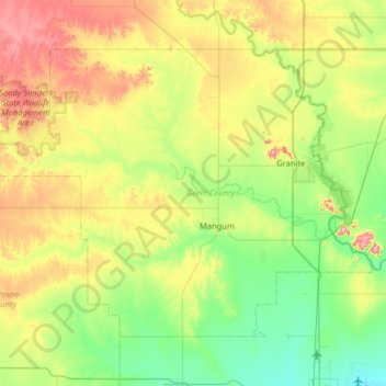
Nom : Carte topographique Greer County, altitude, relief.
Lieu : Greer County, Oklahoma, United States of America (34.72463 -99.88827 35.11698 -99.24667)
Altitude moyenne : 504 m
Altitude minimum : 411 m
Altitude maximum : 705 m
Autres cartes topographiques
Cliquez sur une carte pour visualiser sa topographie, son altitude et son relief.
Skiatook Lake
United States of America > Oklahoma > Morgans Corner
Skiatook Lake, Major General Clarence L. Tinker Memorial Highway, Morgans Corner, Osage County, Oklahoma, United States of America
Altitude moyenne : 228 m
Porum
United States of America > Oklahoma > Porum
Porum, Muskogee County, Oklahoma, 74455, United States of America
Altitude moyenne : 181 m
Idabel
United States of America > Oklahoma > Idabel
Idabel, McCurtain County, Oklahoma, 74745, United States of America
Altitude moyenne : 132 m
Woodall
United States of America > Oklahoma
Woodall, Cherokee County, Oklahoma, United States of America
Altitude moyenne : 232 m
Guymon
United States of America > Oklahoma > Guymon
Guymon, Texas, Oklahoma, United States of America
Altitude moyenne : 933 m
Coalgate
United States of America > Oklahoma > Coalgate
Coalgate, Coal County, Oklahoma, 74538, United States of America
Altitude moyenne : 186 m
Foss
United States of America > Oklahoma > Foss
Foss, Washita County, Oklahoma, United States of America
Altitude moyenne : 508 m
Wynnewood
United States of America > Oklahoma > Wynnewood
Wynnewood, Oklahoma, 73098, United States of America
Altitude moyenne : 271 m
Bethany
United States of America > Oklahoma > Bethany
Bethany, Oklahoma County, Oklahoma, United States of America
Altitude moyenne : 396 m