
Carte topographique Big Foot Beach State Park
Carte interactive
Cliquez sur la carte pour afficher l’altitude.
À propos de cette carte
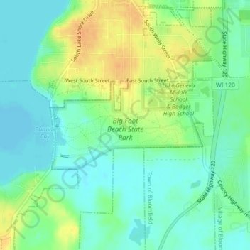
Nom : Carte topographique Big Foot Beach State Park, altitude, relief.
Altitude moyenne : 276 m
Altitude minimum : 262 m
Altitude maximum : 297 m
Autres cartes topographiques
Cliquez sur une carte pour visualiser sa topographie, son altitude et son relief.
Geneva Lake
United States > Wisconsin > Walworth County > Lake Geneva
Geneva Lake, Lake Geneva, Town of Linn, Walworth County, Wisconsin, 53125, United States
Altitude moyenne : 288 m