
Carte topographique Janské Lázně
Carte interactive
Cliquez sur la carte pour afficher l’altitude.
Janské Lázně
Janské Lázně is located about 11 km (7 mi) northwest of Trutnov and 46 km (29 mi) north of Hradec Králové. It lies in the Giant Mountains, and its northern part lies in the Krkonoše National Park. The highest point is the mountain Černá hora with an elevation of 1,299 m (4,262 ft). The Janský Creek springs here and flows through the municipality.
À propos de cette carte
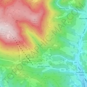
Nom : Carte topographique Janské Lázně, altitude, relief.
Altitude moyenne : 821 m
Altitude minimum : 505 m
Altitude maximum : 1’303 m