
Carte topographique Roborough
Cliquez sur la carte pour afficher l’altitude.
À propos de cette carte
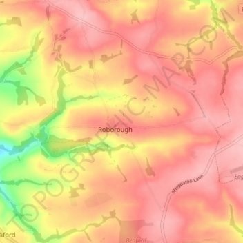
Nom : Carte topographique Roborough, altitude, relief.
Lieu : Roborough, Torridge District, Devon, England, United Kingdom (50.91795 -4.06361 50.95582 -3.99320)
Altitude moyenne : 159 m
Altitude minimum : 70 m
Altitude maximum : 199 m
Autres cartes topographiques
Cliquez sur une carte pour visualiser sa topographie, son altitude et son relief.
Hartland Point
United Kingdom > England > Devon > Torridge District > Hartland
Altitude moyenne : 20 m
Woollaton
United Kingdom > England > Devon > Torridge District > Peters Marland
Altitude moyenne : 138 m