Géolocaliser

Carte topographique Longleng

Cliquez sur la carte pour afficher l’altitude.

À propos de cette carte

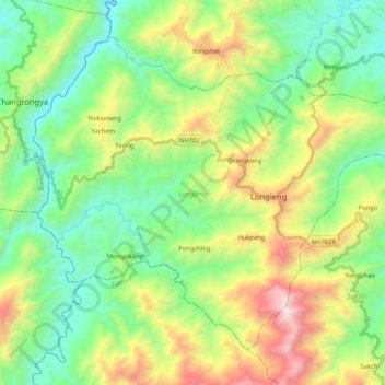
Nom : Carte topographique Longleng, altitude, relief.

Lieu : Longleng, Nagaland, 798625, India (26.41499 94.68567 26.56640 94.89401)

Altitude moyenne : 788 m

Altitude minimum : 237 m

Altitude maximum : 1’941 m

Autres cartes topographiques

Cliquez sur une carte pour visualiser sa topographie, son altitude et son relief.

Dimapur

India > Nagaland > Dimapur Sadar

Altitude moyenne : 204 m

Tanhai

India > Nagaland > Mon

Altitude moyenne : 704 m

Mongsenyimti

India > Nagaland > Chuchuyimlang

Altitude moyenne : 1’005 m

Chiephobozou

India > Nagaland > Chiephobozou

Altitude moyenne : 1’189 m

Chumukedima

India > Nagaland > Chumukedima

Altitude moyenne : 251 m

Kohima

India > Nagaland > Kohima Sadar

Kohima district is the land of the Angami Naga and Rengma Naga tribe. It is situated in the foothills of Japfu range located south of Kohima District (25°40′N 94°07′E / 25.67°N 94.12°E / 25.67; 94.12) and has an average elevation of 1,261 metres (4137 feet).

Altitude moyenne : 1’425 m

Mokokchung

India > Nagaland > ONGPANGKONG (N)

Mokokchung is located at 26°20′N 94°32′E / 26.33°N 94.53°E / 26.33; 94.53. It is located at an elevation of 1325 metres above sea level.

Altitude moyenne : 1’027 m

Sechu Zubza

India > Nagaland > Sechu-Zubza > Sechu Zubza

Altitude moyenne : 1’004 m

Doyang

India > Nagaland > Sanis > Sanis

Altitude moyenne : 552 m

Doyang HEP Dam

India > Nagaland > Englan

Altitude moyenne : 365 m

Kigwema Town

India > Nagaland > Jakhama > Kigwema Town

Altitude moyenne : 1’688 m

Kohīma

India > Nagaland

Altitude moyenne : 1’001 m

Phek

India > Nagaland

Altitude moyenne : 1’134 m

Équipez-vous pour votre prochaine aventure :

🧥Veste coupe-vent - Protection légère contre les courants d'air sur les crêtes
🧤Sous-vêtements techniques - Gestion thermique en effort
🏕️Tentes de randonnée - Tentes légères pour bivouac et trekking
🎥Caméra d'action - Filmez vos descentes et vos ascensions en haute définition
📚Guides de randonnée Alpes - Itinéraires et conseils

En tant que Partenaire Amazon, ce site perçoit une commission sur les achats éligibles sans surcoût pour vous.