
Carte topographique Wroughton
Cliquez sur la carte pour afficher l’altitude.
À propos de cette carte
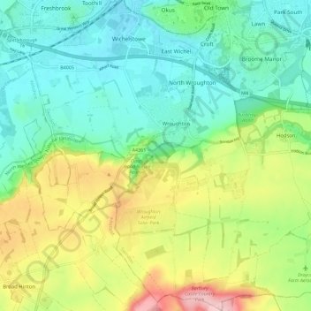
Nom : Carte topographique Wroughton, altitude, relief.
Lieu : Wroughton, Swindon, England, United Kingdom (51.48246 -1.84692 51.55323 -1.76425)
Altitude moyenne : 153 m
Altitude minimum : 95 m
Altitude maximum : 269 m
Autres cartes topographiques
Cliquez sur une carte pour visualiser sa topographie, son altitude et son relief.
Swindon
United Kingdom > England > Swindon
Swindon has an oceanic climate (Cfb in the Köppen climate classification), like the vast majority of the British Isles, with cool winters and warm summers. The nearest official weather station is RAF Lyneham, about 10 miles (16 km) west southwest of Swindon town centre. The weather station's elevation is 145…
Altitude moyenne : 108 m