
Faire un don
Équipez-vous pour votre prochaine aventure :
En tant que Partenaire Amazon, ce site perçoit une commission sur les achats éligibles sans surcoût pour vous.
Carte topographique Nanjanagudu
Cliquez sur la carte pour afficher l’altitude.
Faire un don
Équipez-vous pour votre prochaine aventure :
En tant que Partenaire Amazon, ce site perçoit une commission sur les achats éligibles sans surcoût pour vous.
Nanjanagudu
Nanjangud is located at 15°07′N 76°41′E / 15.12°N 76.68°E / 15.12; 76.68. It has an average elevation of 657 metres (2155 ft). The taluk borders Mysore taluk of Mysore district to the north, T Narsipur taluk of Mysore district to the east, H D Kote taluk of Mysore district to the west and Gundlupet and Chamarajanagar taluks of Chamarajanagar district to the south.
Faire un don
Équipez-vous pour votre prochaine aventure :
En tant que Partenaire Amazon, ce site perçoit une commission sur les achats éligibles sans surcoût pour vous.
À propos de cette carte
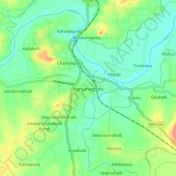
Nom : Carte topographique Nanjanagudu, altitude, relief.
Altitude moyenne : 667 m
Altitude minimum : 641 m
Altitude maximum : 725 m
Faire un don
Équipez-vous pour votre prochaine aventure :
En tant que Partenaire Amazon, ce site perçoit une commission sur les achats éligibles sans surcoût pour vous.