
Carte topographique Annapolis
Carte interactive
Cliquez sur la carte pour afficher l’altitude.
À propos de cette carte
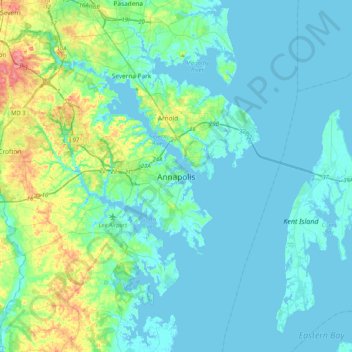
Nom : Carte topographique Annapolis, altitude, relief.
Altitude moyenne : 13 m
Altitude minimum : -3 m
Altitude maximum : 76 m
Annapolis lies within the humid subtropical climate zone (Köppen Cfa), with hot, humid summers, cool winters, and generous precipitation year-round. Low elevation and proximity to the Chesapeake Bay give the area more moderate spring and summertime temperatures and slightly less extreme winter lows than locations further inland, such as Washington, D.C.
Autres cartes topographiques
Cliquez sur une carte pour visualiser sa topographie, son altitude et son relief.
Edgewater
United States > Maryland > Anne Arundel County > Annapolis > Edgewater
Edgewater, Annapolis, Edgewater, Anne Arundel County, Maryland, United States
Altitude moyenne : 7 m
Bay Ridge Junction
United States > Maryland > Anne Arundel County > Annapolis
Bay Ridge Junction, Market Quay, Annapolis, Anne Arundel County, Maryland, 21401, United States
Altitude moyenne : 10 m