
Carte topographique Norwalk
Carte interactive
Cliquez sur la carte pour afficher l’altitude.
Norwalk
Norwalk's topography is dominated by its coastline along Long Island Sound, the Norwalk River and its eastern and western banks, and the Norwalk Islands. The highest elevation is 315 feet (96 m) above sea level on the fairway of the 16th hole of the Silvermine Golf Course, and the low elevation is sea level on Long Island Sound.
À propos de cette carte
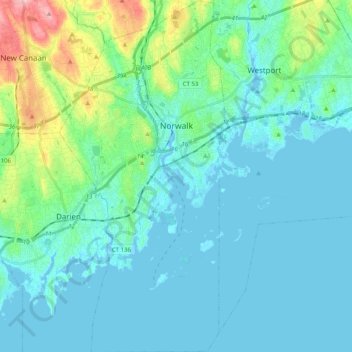
Nom : Carte topographique Norwalk, altitude, relief.
Altitude moyenne : 24 m
Altitude minimum : -7 m
Altitude maximum : 145 m
Autres cartes topographiques
Cliquez sur une carte pour visualiser sa topographie, son altitude et son relief.
King Street
United States > Connecticut > Western Connecticut Planning Region > Danbury
Altitude moyenne : 237 m
South End
United States > Connecticut > Western Connecticut Planning Region > Stamford
Altitude moyenne : 11 m
Long Ridge
United States > Connecticut > Western Connecticut Planning Region > Stamford
Altitude moyenne : 126 m
Wataba Lake
United States > Connecticut > Western Connecticut Planning Region > Ridgefield
Altitude moyenne : 205 m
Byram
United States > Connecticut > Western Connecticut Planning Region > Greenwich
Altitude moyenne : 19 m
West Norwalk
United States > Connecticut > Western Connecticut Planning Region > Norwalk
Altitude moyenne : 50 m
Deer Hill
United States > Connecticut > Western Connecticut Planning Region > Danbury
Altitude moyenne : 135 m
Godfrey Corner
United States > Connecticut > Western Connecticut Planning Region > Weston
Altitude moyenne : 110 m
Town Open Space (Ashford Lane)
United States > Connecticut > Western Connecticut Planning Region > Newtown
Altitude moyenne : 200 m
Roxbury
United States > Connecticut > Western Connecticut Planning Region > Stamford
Altitude moyenne : 48 m
Glenville
United States > Connecticut > Western Connecticut Planning Region > Greenwich
Altitude moyenne : 54 m
North Stamford
United States > Connecticut > Western Connecticut Planning Region > Stamford
Altitude moyenne : 89 m
Palmers Hill
United States > Connecticut > Western Connecticut Planning Region > Stamford
Altitude moyenne : 31 m
Belltown
United States > Connecticut > Western Connecticut Planning Region > Stamford
Altitude moyenne : 32 m
Mianus
United States > Connecticut > Western Connecticut Planning Region > Greenwich
Altitude moyenne : 23 m
Taylor Corners
United States > Connecticut > Western Connecticut Planning Region > New Fairfield
Altitude moyenne : 226 m
Contentment Island
United States > Connecticut > Western Connecticut Planning Region > Darien
Altitude moyenne : 63 m
Beckettville
United States > Connecticut > Western Connecticut Planning Region > Danbury
Altitude moyenne : 155 m
Candlewood Orchards
United States > Connecticut > Western Connecticut Planning Region > Brookfield
Altitude moyenne : 141 m
Riverside
United States > Connecticut > Western Connecticut Planning Region > Greenwich
Altitude moyenne : 13 m
Candlewood Springs
United States > Connecticut > Western Connecticut Planning Region > New Milford
Altitude moyenne : 146 m
Byram
United States > Connecticut > Western Connecticut Planning Region > Greenwich
Altitude moyenne : 19 m
Ponus
United States > Connecticut > Western Connecticut Planning Region > New Canaan
Altitude moyenne : 77 m
Old Baldy
United States > Connecticut > Western Connecticut Planning Region > Norwalk
Altitude moyenne : 59 m
Hunting Ridge
United States > Connecticut > Western Connecticut Planning Region > Stamford
Altitude moyenne : 81 m
Riverbank
United States > Connecticut > Western Connecticut Planning Region > Stamford
Altitude moyenne : 72 m
Honey Hill
United States > Connecticut > Western Connecticut Planning Region > Wilton
Altitude moyenne : 126 m