
Carte topographique Niihau
Carte interactive
Cliquez sur la carte pour afficher l’altitude.
À propos de cette carte
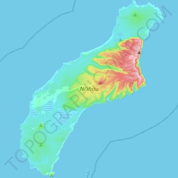
Nom : Carte topographique Niihau, altitude, relief.
Lieu : Niihau, Puuwai, Kauaʻi County, Hawaii, United States (21.77906 -160.24700 22.00540 -160.04962)
Altitude moyenne : 23 m
Altitude minimum : -2 m
Altitude maximum : 386 m
Niʻihau is located about 18 miles (29 km) west of Kauaʻi, and the tiny, uninhabited island of Lehua lies 0.7 miles (0.61 nmi; 1.1 km) north of Niʻihau. Niʻihau's dimensions are 6.2 miles by 18.6 miles (10 km × 30 km). The maximum elevation (Paniau) is 1,280 feet (390 m). The island is about 6 million years old, making it geologically older than the 5.8-million-year-old neighboring island of Kauaʻi to the northeast. Niʻihau is the remnant of the southwestern slope of what was once a much larger volcano. The entire summit and other slopes collapsed into the ocean in a giant prehistoric landslide.