
Faire un don
Équipez-vous pour votre prochaine aventure :
En tant que Partenaire Amazon, ce site perçoit une commission sur les achats éligibles sans surcoût pour vous.
Carte topographique Acton
Cliquez sur la carte pour afficher l’altitude.
Faire un don
Équipez-vous pour votre prochaine aventure :
En tant que Partenaire Amazon, ce site perçoit une commission sur les achats éligibles sans surcoût pour vous.
À propos de cette carte
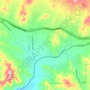
Nom : Carte topographique Acton, altitude, relief.
Altitude moyenne : 947 m
Altitude minimum : 785 m
Altitude maximum : 1’253 m
Faire un don
Équipez-vous pour votre prochaine aventure :
En tant que Partenaire Amazon, ce site perçoit une commission sur les achats éligibles sans surcoût pour vous.
Autres cartes topographiques
Cliquez sur une carte pour visualiser sa topographie, son altitude et son relief.
Los Angeles
United States > California > Los Angeles County
Los Angeles is characterized by a diverse and dynamic topography. The city is predominantly situated in a basin bordered by mountain ranges, including the Santa Monica Mountains to the north and the San Gabriel Mountains to the east, with elevations reaching up to about 10,000 feet (3,048 meters) in certain…
Altitude moyenne : 241 m
Pasadena
United States > California > Los Angeles County
An obscure portion of the Angeles Crest Highway (SR 2) in the San Gabriel Mountains cuts through Pasadena near the Angeles Crest Ranger Station. This 2-mile (3.2 km) stretch of highway in the Angeles National Forest is north of La Cañada Flintridge and west of Mount Wilson and is approximately 3,000 feet (910…
Altitude moyenne : 548 m
Faire un don
Équipez-vous pour votre prochaine aventure :
En tant que Partenaire Amazon, ce site perçoit une commission sur les achats éligibles sans surcoût pour vous.
Malibu
United States > California > Los Angeles County
The Malibu Coast lies on the fringe of an extensive chaparral and woodland wilderness area, the Santa Monica Mountains National Recreation Area. Various environmental elements collectively create a recipe for natural disasters: the mountainous and geologically unstable terrain; seasonal rainstorms that result…
Altitude moyenne : 144 m
La Cañada Flintridge
United States > California > Los Angeles County
La Cañada Flintridge varies in elevation from about 970 feet (300 m) just below Devil's Gate Dam in the Arroyo Seco to about 2,400 feet (730 m) at the highest neighborhood, along the mountain front east of Pickens Canyon, at the upper end of Ocean View Blvd. The city limits extend into the San Gabriel…
Altitude moyenne : 503 m
Whittier
United States > California > Los Angeles County
Whittier is about 15 miles (24 km) inland of the Pacific Ocean, resulting in higher daytime temperatures, and since it lies at a higher elevation than the cities further west, cold air drains into the lower elevation of the Los Angeles Basin which results in warmer night-time lows, producing an example of…
Altitude moyenne : 115 m
Faire un don
Équipez-vous pour votre prochaine aventure :
En tant que Partenaire Amazon, ce site perçoit une commission sur les achats éligibles sans surcoût pour vous.
Santa Clarita
United States > California > Los Angeles County
The official elevation of the city is 1,207 feet (368 m), the elevation of the historic Newhall Airport which was northwest of Via Princessa and Railroad Avenue from the 1930s through the 1950s. Elevation varies substantially throughout the city. The lowest point in Santa Clarita is near the junction of CA-126…
Altitude moyenne : 514 m
Santa Catalina Island
United States > California > Los Angeles County > Avalon
Catalina is primarily composed of two distinct rock units: Catalina Schist from the Early Cretaceous (95 to 109 million years ago), and Miocene volcanic and intrusive igneous rocks. The island is rich in quartz, to the extent that some beaches on the seaward side have silvery-grey sand. These formations…
Altitude moyenne : 60 m
Faire un don
Équipez-vous pour votre prochaine aventure :
En tant que Partenaire Amazon, ce site perçoit une commission sur les achats éligibles sans surcoût pour vous.
Faire un don
Équipez-vous pour votre prochaine aventure :
En tant que Partenaire Amazon, ce site perçoit une commission sur les achats éligibles sans surcoût pour vous.
Studio City Neighborhood Council District
United States > California > Los Angeles County > Los Angeles
Altitude moyenne : 255 m
Malibu
United States > California > Los Angeles County
The Malibu Coast lies on the fringe of an extensive chaparral and woodland wilderness area, the Santa Monica Mountains National Recreation Area. Various environmental elements collectively create a recipe for natural disasters: the mountainous and geologically unstable terrain; seasonal rainstorms that result…
Altitude moyenne : 144 m
Faire un don
Équipez-vous pour votre prochaine aventure :
En tant que Partenaire Amazon, ce site perçoit une commission sur les achats éligibles sans surcoût pour vous.
Long Beach
United States > California > Los Angeles County
Willow Springs Park was founded as a part of the Willow Springs Wetlands Restoration Project which opened in October 2017. The project restored 11 acres of a 48-acre degraded oil well site into wetlands. These highlight the pivotal role the ecosystem played in the City of Long Beach’s establishment in the…
Altitude moyenne : 12 m
Faire un don
Équipez-vous pour votre prochaine aventure :
En tant que Partenaire Amazon, ce site perçoit une commission sur les achats éligibles sans surcoût pour vous.
Green Valley
United States > California > Los Angeles County
Green Valley is an unincorporated community and census-designated place (CDP) in the Sierra Pelona Mountains, in Los Angeles County, California. It lies at an elevation of 2936 feet (895 m). The population was 1,036 at the 2020 census, up from 1,027 at the 2010 census.
Altitude moyenne : 1’057 m
Porter Ranch Neighborhood Council District
United States > California > Los Angeles County > Los Angeles
Altitude moyenne : 460 m
Faire un don
Équipez-vous pour votre prochaine aventure :
En tant que Partenaire Amazon, ce site perçoit une commission sur les achats éligibles sans surcoût pour vous.
Mount Baden-Powell
United States > California > Los Angeles County
At 9,407 feet (2,867 m) in elevation, Mount Baden-Powell is traditionally considered to be the 5th highest peak of the San Gabriel Range; however it is the second highest peak in the range with more than 1,000 feet (300 m) of prominence, and is the highest peak not part of the Mount San Antonio massif.
Altitude moyenne : 2’429 m
Faire un don
Équipez-vous pour votre prochaine aventure :
En tant que Partenaire Amazon, ce site perçoit une commission sur les achats éligibles sans surcoût pour vous.
Point Dume
United States > California > Los Angeles County > Malibu
Offshore, the nutrient-rich and frigid waters of the Pacific enhance the entire marine food web, from primary producers such as algae and zooplankton to apex predators like sand sharks, bottlenose dolphins, and gray whales. Within the Marine Protected Areas (MPAs), the diverse seafloor topography encompasses…
Altitude moyenne : 12 m
Encino Neighborhood Council District
United States > California > Los Angeles County > Los Angeles
Altitude moyenne : 288 m
Oak Hill
United States > California > Los Angeles County > Unincorporated Santa Monica Mountains
Altitude moyenne : 478 m
Faire un don
Équipez-vous pour votre prochaine aventure :
En tant que Partenaire Amazon, ce site perçoit une commission sur les achats éligibles sans surcoût pour vous.
Faire un don
Équipez-vous pour votre prochaine aventure :
En tant que Partenaire Amazon, ce site perçoit une commission sur les achats éligibles sans surcoût pour vous.
Faire un don
Équipez-vous pour votre prochaine aventure :
En tant que Partenaire Amazon, ce site perçoit une commission sur les achats éligibles sans surcoût pour vous.
Long Beach
United States > California > Los Angeles County
Willow Springs Park was founded as a part of the Willow Springs Wetlands Restoration Project which opened in October 2017. The project restored 11 acres of a 48-acre degraded oil well site into wetlands. These highlight the pivotal role the ecosystem played in the City of Long Beach’s establishment in the…
Altitude moyenne : 12 m
Faire un don
Équipez-vous pour votre prochaine aventure :
En tant que Partenaire Amazon, ce site perçoit une commission sur les achats éligibles sans surcoût pour vous.
Burbank
United States > California > Los Angeles County
Elevations in the city range from 500 feet (150 m) in the lower valley areas to about 800 feet (240 m) near the Verdugo Mountains. Most of Burbank features a water table more than 100 feet (30 m) deep, more than the measures found in the 1940s when the water table was within 50 feet (15 m) of the ground…
Altitude moyenne : 290 m
Los Angeles
United States > California > Los Angeles County
Los Angeles is characterized by a diverse and dynamic topography. The city is predominantly situated in a basin bordered by mountain ranges, including the Santa Monica Mountains to the north and the San Gabriel Mountains to the east, with elevations reaching up to about 10,000 feet (3,048 meters) in certain…
Altitude moyenne : 241 m
Faire un don
Équipez-vous pour votre prochaine aventure :
En tant que Partenaire Amazon, ce site perçoit une commission sur les achats éligibles sans surcoût pour vous.
San Gabriel Mountains National Monument
United States > California > Los Angeles County
Altitude moyenne : 817 m
Faire un don
Équipez-vous pour votre prochaine aventure :
En tant que Partenaire Amazon, ce site perçoit une commission sur les achats éligibles sans surcoût pour vous.
Los Angeles
United States > California > Los Angeles County
Los Angeles is characterized by a diverse and dynamic topography. The city is predominantly situated in a basin bordered by mountain ranges, including the Santa Monica Mountains to the north and the San Gabriel Mountains to the east, with elevations reaching up to about 10,000 feet (3,048 meters) in certain…
Altitude moyenne : 241 m
Unincorporated Santa Monica Mountains
United States > California > Los Angeles County
Altitude moyenne : 215 m
Faire un don
Équipez-vous pour votre prochaine aventure :
En tant que Partenaire Amazon, ce site perçoit une commission sur les achats éligibles sans surcoût pour vous.
Mount San Antonio
United States > California > Los Angeles County
The prehistoric Hog Back landslide lies in the canyon of San Antonio Creek at 4000' elevation. When the slide occurred, it dammed the river, whose depth built up until the water was released catastrophically, forming a slot canyon which now holds some of the area's few good rock climbing routes (difficulty…
Altitude moyenne : 2’675 m
Faire un don
Équipez-vous pour votre prochaine aventure :
En tant que Partenaire Amazon, ce site perçoit une commission sur les achats éligibles sans surcoût pour vous.
Valley Village Neighborhood Council District
United States > California > Los Angeles County > Los Angeles
Altitude moyenne : 199 m
Hungry Valley SVRA
United States > California > Los Angeles County > Gorman
Altitude moyenne : 1’303 m
Faire un don
Équipez-vous pour votre prochaine aventure :
En tant que Partenaire Amazon, ce site perçoit une commission sur les achats éligibles sans surcoût pour vous.
Palos Verdes
United States > California > Los Angeles County > Rancho Palos Verdes
Altitude moyenne : 49 m
Faire un don
Équipez-vous pour votre prochaine aventure :
En tant que Partenaire Amazon, ce site perçoit une commission sur les achats éligibles sans surcoût pour vous.
Canoga Park Neighborhood Council District
United States > California > Los Angeles County > Los Angeles
Altitude moyenne : 255 m
Universal City Overlook
United States > California > Los Angeles County > Los Angeles
Altitude moyenne : 278 m
Green Valley
United States > California > Los Angeles County
Green Valley is an unincorporated community and census-designated place (CDP) in the Sierra Pelona Mountains, in Los Angeles County, California. It lies at an elevation of 2936 feet (895 m). The population was 1,036 at the 2020 census, up from 1,027 at the 2010 census.
Altitude moyenne : 1’067 m
Faire un don
Équipez-vous pour votre prochaine aventure :
En tant que Partenaire Amazon, ce site perçoit une commission sur les achats éligibles sans surcoût pour vous.
Faire un don
Équipez-vous pour votre prochaine aventure :
En tant que Partenaire Amazon, ce site perçoit une commission sur les achats éligibles sans surcoût pour vous.
Pacific Palisades
United States > California > Los Angeles County > Los Angeles
Pacific Palisades was formally founded in 1921 by a Methodist organization, and in the years that followed became a refuge for Jewish artists and intellectuals fleeing the Holocaust. The Palisades would later be sought after by celebrities and other high-profile individuals seeking privacy. It is known for its…
Altitude moyenne : 196 m
Palmdale
United States > California > Los Angeles County
Downtown Palmdale is located at 34°34′46″N 118°07′00″W / 34.57944°N 118.11667°W / 34.57944; -118.11667, at an elevation of 2,655 feet (809 m) above sea level.
Altitude moyenne : 898 m
Faire un don
Équipez-vous pour votre prochaine aventure :
En tant que Partenaire Amazon, ce site perçoit une commission sur les achats éligibles sans surcoût pour vous.
Van Nuys Neighborhood Council District
United States > California > Los Angeles County > Los Angeles
Altitude moyenne : 224 m
Sierra Madre
United States > California > Los Angeles County
In 1908, the first Mt. Wilson Trail Race was run. This annual race was discontinued during WWII and reestablished in 1966. The 102nd anniversary of the first running of the Mount Wilson Trail Race and the 44th annual race was run in May 2010. Because of rain, mudslides, falling trees, soil erosion and…
Altitude moyenne : 361 m
Faire un don
Équipez-vous pour votre prochaine aventure :
En tant que Partenaire Amazon, ce site perçoit une commission sur les achats éligibles sans surcoût pour vous.
Faire un don
Équipez-vous pour votre prochaine aventure :
En tant que Partenaire Amazon, ce site perçoit une commission sur les achats éligibles sans surcoût pour vous.
Winnetka Neighborhood Council District
United States > California > Los Angeles County > Los Angeles
Altitude moyenne : 244 m
Faire un don
Équipez-vous pour votre prochaine aventure :
En tant que Partenaire Amazon, ce site perçoit une commission sur les achats éligibles sans surcoût pour vous.