
Carte topographique Carracedo
Carte interactive
Cliquez sur la carte pour afficher l’altitude.
À propos de cette carte
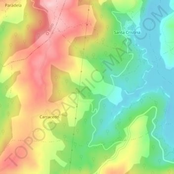
Nom : Carte topographique Carracedo, altitude, relief.
Lieu : Carracedo, A Veiga, Valdeorras, Orense, Galicia, España (42.24697 -7.07189 42.26596 -7.03526)
Altitude moyenne : 927 m
Altitude minimum : 833 m
Altitude maximum : 1’041 m
Autres cartes topographiques
Cliquez sur une carte pour visualiser sa topographie, son altitude et son relief.
Xares
España > Galicia > Valdeorras > A Veiga
Xares, A Veiga, Valdeorras, Orense, Galicia, 32365, España
Altitude moyenne : 1’273 m
Valdín
España > Galicia > Valdeorras > A Veiga
Valdín, A Veiga, Valdeorras, Orense, Galicia, España
Altitude moyenne : 1’263 m
Lamalonga
España > Galicia > Valdeorras > A Veiga
Lamalonga, A Veiga, Valdeorras, Orense, Galicia, España
Altitude moyenne : 1’274 m
Espiño
España > Galicia > Valdeorras > A Veiga
Espiño, A Veiga, Valdeorras, Orense, Galicia, España
Altitude moyenne : 1’146 m
ZEC Pena Trevinca
España > Galicia > Valdeorras > A Veiga
ZEC Pena Trevinca, Valdín, A Veiga, Valdeorras, Orense, Galicia, 32369, España
Altitude moyenne : 1’223 m