
Carte topographique Deer Park
Carte interactive
Cliquez sur la carte pour afficher l’altitude.
À propos de cette carte
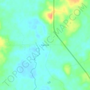
Nom : Carte topographique Deer Park, altitude, relief.
Lieu : Deer Park, Washington County, Alabama, United States (31.19684 -88.33723 31.23684 -88.29723)
Altitude moyenne : 48 m
Altitude minimum : 36 m
Altitude maximum : 79 m
Autres cartes topographiques
Cliquez sur une carte pour visualiser sa topographie, son altitude et son relief.
Walley
United States > Alabama > Washington County
Walley, Washington County, Alabama, United States
Altitude moyenne : 73 m
Chatom
United States > Alabama > Washington County
Chatom, Washington County, Alabama, 36518, United States
Altitude moyenne : 48 m
Tibbie
United States > Alabama > Washington County > Tibbie
Tibbie, Washington County, Alabama, 36583, United States
Altitude moyenne : 55 m
McIntosh
United States > Alabama > Washington County > McIntosh
McIntosh, Washington County, Alabama, United States
Altitude moyenne : 13 m
Carson
United States > Alabama > Washington County
Carson, Washington County, Alabama, 36548, United States
Altitude moyenne : 18 m