
Carte topographique Immenstedt
Carte interactive
Cliquez sur la carte pour afficher l’altitude.
À propos de cette carte
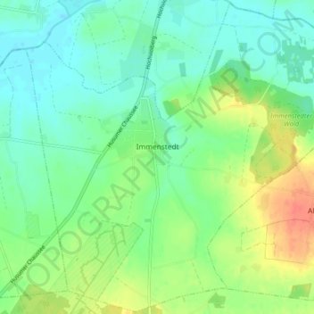
Nom : Carte topographique Immenstedt, altitude, relief.
Lieu : Immenstedt, Viöl, Nordfriesland, Sleeswijk-Holstein, Duitsland (54.51494 9.12977 54.56055 9.20947)
Altitude moyenne : 17 m
Altitude minimum : 1 m
Altitude maximum : 47 m
Autres cartes topographiques
Cliquez sur une carte pour visualiser sa topographie, son altitude et son relief.
Frederikstad aan de Eider
Duitsland > Sleeswijk-Holstein > Nordfriesland
Frederikstad aan de Eider, Nordfriesland, Sleeswijk-Holstein, 25840, Duitsland
Altitude moyenne : 2 m
Fahretoft
Duitsland > Sleeswijk-Holstein > Nordfriesland
Fahretoft, Dagebüll, Südtondern, Nordfriesland, Sleeswijk-Holstein, Duitsland
Altitude moyenne : -1 m
Westerheide
Duitsland > Sleeswijk-Holstein > Nordfriesland > List auf Sylt > Westerheide
Westerheide, List auf Sylt, Landschaft Sylt, Nordfriesland, Sleeswijk-Holstein, 25992, Duitsland
Altitude moyenne : 2 m
Pellworm
Duitsland > Sleeswijk-Holstein > Nordfriesland > Pellworm
Pellworm, Nordfriesland, Sleeswijk-Holstein, 25849, Duitsland
Altitude moyenne : 0 m
Bargum
Duitsland > Sleeswijk-Holstein > Nordfriesland > Bargum
Bargum, Mittleres Nordfriesland, Nordfriesland, Sleeswijk-Holstein, Duitsland
Altitude moyenne : 3 m
Westerland
Duitsland > Sleeswijk-Holstein > Nordfriesland > Sylt
Westerland, Sylt, Nordfriesland, Sleeswijk-Holstein, Duitsland
Altitude moyenne : 3 m
Midlum
Duitsland > Sleeswijk-Holstein > Nordfriesland
Midlum, Föhr-Amrum, Nordfriesland, Sleeswijk-Holstein, Duitsland
Altitude moyenne : 1 m
Neukirchen
Duitsland > Sleeswijk-Holstein > Nordfriesland
Neukirchen, Südtondern, Nordfriesland, Sleeswijk-Holstein, 25927, Duitsland
Altitude moyenne : 0 m
Sylt
Duitsland > Sleeswijk-Holstein > Nordfriesland
Sylt, Nordfriesland, Sleeswijk-Holstein, Duitsland
Altitude moyenne : 0 m