
Carte topographique Aldo Leopold Wilderness
Carte interactive
Cliquez sur la carte pour afficher l’altitude.
À propos de cette carte
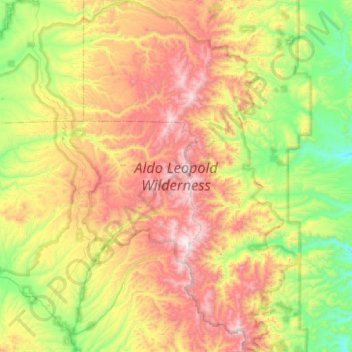
Nom : Carte topographique Aldo Leopold Wilderness, altitude, relief.
Altitude moyenne : 2’249 m
Altitude minimum : 1’695 m
Altitude maximum : 3’091 m
The Aldo Leopold Wilderness area stretches north-south along the crest of the Black Range for about 30 miles (48 km) and has a maximum width of about 15 miles (24 km). The elevation of the crest ranges from 8,600 to 10,165 feet (2,621 to 3,098 m) at McKnight Mountain, the highest point in the wilderness area. The crest of the range overlooks a series of east-west trending steep and narrow stream valleys, one thousand or more feet deep. The lowest elevation in the wilderness is about 6,000 feet (1,830 m). Vegetation in the Aldo Leopold consists of a spruce-fir and quaking aspen forest above 9,000 feet (2,740 m), a ponderosa pine forest between 6,500 and 9,000 feet (2,000 and 2,700 m) and a pinyon-juniper woodland and desert vegetation below 6,500 feet and on dry southern slopes. Hardwood forests, especially cottonwood, line many of the larger streams.
Autres cartes topographiques
Cliquez sur une carte pour visualiser sa topographie, son altitude et son relief.
Silver City
United States > New Mexico > Grant County
Silver City, Grant County, New Mexico, 88062, United States
Altitude moyenne : 1’850 m
Hurley
United States > New Mexico > Grant County
Hurley, Grant County, New Mexico, United States
Altitude moyenne : 1’734 m
Bayard
United States > New Mexico > Grant County
Bayard, Grant County, New Mexico, 88023, United States
Altitude moyenne : 1’816 m
Arenas Valley
United States > New Mexico > Grant County > Silver City
Arenas Valley, Silver City, Grant County, New Mexico, 88022, United States
Altitude moyenne : 1’873 m
Santa Clara
United States > New Mexico > Grant County
Santa Clara, Grant County, New Mexico, 88026, United States
Altitude moyenne : 1’833 m
Mallet Pond
United States > New Mexico > Grant County
Mallet Pond, Grant County, New Mexico, United States
Altitude moyenne : 1’802 m
Dwyer
United States > New Mexico > Grant County
Dwyer, Grant County, New Mexico, 88034, United States
Altitude moyenne : 1’616 m
Pinos Altos
United States > New Mexico > Grant County
Pinos Altos, Grant County, New Mexico, 88053, United States
Altitude moyenne : 2’142 m