
Carte topographique Texas
Carte interactive
Cliquez sur la carte pour afficher l’altitude.
À propos de cette carte
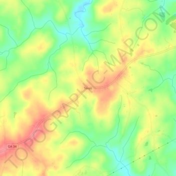
Nom : Carte topographique Texas, altitude, relief.
Lieu : Texas, Heard County, Georgia, United States (33.22095 -85.21883 33.26095 -85.17883)
Altitude moyenne : 258 m
Altitude minimum : 214 m
Altitude maximum : 302 m
Autres cartes topographiques
Cliquez sur une carte pour visualiser sa topographie, son altitude et son relief.
Glenn
United States > Georgia > Heard County
Glenn, Heard County, Georgia, United States
Altitude moyenne : 239 m
Houston
United States > Georgia > Heard County
Houston, Heard County, Georgia, 30219, United States
Altitude moyenne : 229 m
Cooksville
United States > Georgia > Heard County
Cooksville, Heard County, Georgia, United States
Altitude moyenne : 212 m
Glenloch
United States > Georgia > Heard County
Glenloch, Heard County, Georgia, United States
Altitude moyenne : 289 m
Roosterville
United States > Georgia > Heard County
Roosterville, Heard County, Georgia, 30170, United States
Altitude moyenne : 302 m
Viola
United States > Georgia > Heard County
Viola, Heard County, Georgia, United States
Altitude moyenne : 237 m
Owensbyville
United States > Georgia > Heard County
Owensbyville, Heard County, Georgia, United States
Altitude moyenne : 214 m
Centralhatchee
United States > Georgia > Heard County
Centralhatchee, Heard County, Georgia, United States
Altitude moyenne : 252 m
Yellow Dirt
United States > Georgia > Heard County
Yellow Dirt, Heard County, Georgia, United States
Altitude moyenne : 237 m
Franklin
United States > Georgia > Heard County
Franklin, Heard County, Georgia, United States
Altitude moyenne : 223 m
Ephesus
United States > Georgia > Heard County
Ephesus, Heard County, Georgia, United States
Altitude moyenne : 360 m
Corinth
United States > Georgia > Heard County
Corinth, Heard County, Georgia, United States
Altitude moyenne : 233 m