
Carte topographique Stang Top
Cliquez sur la carte pour afficher l’altitude.
À propos de cette carte
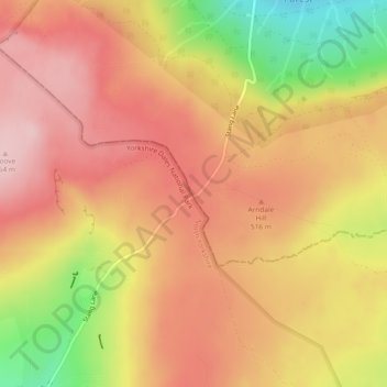
Nom : Carte topographique Stang Top, altitude, relief.
Altitude moyenne : 479 m
Altitude minimum : 352 m
Altitude maximum : 551 m
Autres cartes topographiques
Cliquez sur une carte pour visualiser sa topographie, son altitude et son relief.
South Agnew Plantation
United Kingdom > England > County Durham > Newton Aycliffe
Altitude moyenne : 100 m
Derwent Gorge and Muggleswick Woods National Nature Reserve
United Kingdom > England > County Durham > Castleside > Healeyfield
Altitude moyenne : 214 m
Great High Wood
United Kingdom > England > County Durham > Durham > High Shincliffe
Altitude moyenne : 63 m
Flass Vale Local Nature Reserve
United Kingdom > England > County Durham > Durham
Altitude moyenne : 81 m
Bishop Middleham Quarry Nature Reserve
United Kingdom > England > County Durham > Bishop Middleham
Altitude moyenne : 115 m
Oakey's Park
United Kingdom > England > County Durham > Stanley > West Shield Row Villas
Altitude moyenne : 182 m
Tunstall Reservoir
United Kingdom > England > County Durham > Wolsingham
The reservoir was created for the Weardale and Shildon District Waterworks Company, with construction of the dam between 1873 and 1879.[2][3] The earth embankment dam was built across the valley of Waskerley Beck, and measures 1,020 feet (310 m) long and 82 feet (25 m) high. It was constructed with a puddle…
Altitude moyenne : 288 m