
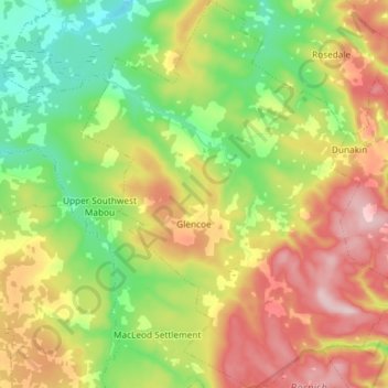
Carte topographique Glencoe
Carte interactive
Cliquez sur la carte pour afficher l’altitude.
À propos de cette carte
Nom : Carte topographique Glencoe, altitude, relief.
Altitude moyenne : 158 m
Altitude minimum : 42 m
Altitude maximum : 307 m
Autres cartes topographiques
Cliquez sur une carte pour visualiser sa topographie, son altitude et son relief.
Broad Cove Chapel
Canada > Nova Scotia > Municipality of the County of Inverness
Broad Cove Chapel, Municipality of the County of Inverness, Inverness County, Nova Scotia, Canada
Altitude moyenne : 84 m
Marble Mountain
Canada > Nova Scotia > Municipality of the County of Inverness
Marble Mountain, Municipality of the County of Inverness, Inverness County, Nova Scotia, Canada
Altitude moyenne : 55 m
Big Harbour Island
Canada > Nova Scotia > Municipality of the County of Inverness
Big Harbour Island, Municipality of the County of Inverness, Inverness County, Nova Scotia, Canada
Altitude moyenne : 3 m
Margaree Valley
Canada > Nova Scotia > Municipality of the County of Inverness
Margaree Valley, Municipality of the County of Inverness, Inverness County, Nova Scotia, Canada
Altitude moyenne : 223 m
Margaree Forks
Canada > Nova Scotia > Municipality of the County of Inverness > Margaree Forks
Margaree Forks, Municipality of the County of Inverness, Inverness County, Nova Scotia, Canada
Altitude moyenne : 134 m
Margaree
Canada > Nova Scotia > Municipality of the County of Inverness > Margaree
Margaree, Municipality of the County of Inverness, Inverness County, Nova Scotia, Canada
Altitude moyenne : 149 m
Mabou
Canada > Nova Scotia > Municipality of the County of Inverness
Mabou, Municipality of the County of Inverness, Inverness County, Nova Scotia, Canada
Altitude moyenne : 81 m
Troy
Canada > Nova Scotia > Municipality of the County of Inverness
Troy, Municipality of the County of Inverness, Inverness County, Nova Scotia, Canada
Altitude moyenne : 81 m
Meat Cove
Canada > Nova Scotia > Municipality of the County of Inverness > Meat Cove
Meat Cove, Municipality of the County of Inverness, Inverness County, Nova Scotia, B0C 1E0, Canada
Altitude moyenne : 212 m