
Carte topographique Dromod
Carte interactive
Cliquez sur la carte pour afficher l’altitude.
À propos de cette carte
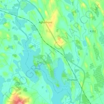
Nom : Carte topographique Dromod, altitude, relief.
Altitude moyenne : 49 m
Altitude minimum : 33 m
Altitude maximum : 116 m
Autres cartes topographiques
Cliquez sur une carte pour visualiser sa topographie, son altitude et son relief.
Leckaun
Leckaun, Drumkeeran ED, Manorhamilton Municipal District, County Leitrim, Connacht, Ireland
Altitude moyenne : 220 m
Glenfarne
Glenfarne, Glenfarn ED, Manorhamilton Municipal District, County Leitrim, Connacht, Ireland
Altitude moyenne : 90 m
Glenade
Glenade, Aghalateeve ED, Manorhamilton Municipal District, County Leitrim, Connacht, Ireland
Altitude moyenne : 163 m
Manorhamilton
Manorhamilton, Manorhamilton ED, Manorhamilton Municipal District, County Leitrim, Connacht, Ireland
Altitude moyenne : 70 m
Knockacullion
Knockacullion, Ballinamore Municipal District, County Leitrim, Connacht, Ireland
Altitude moyenne : 443 m
Aghacashel
Aghacashel, Aghacashel ED, Ballinamore Municipal District, County Leitrim, Connacht, Ireland
Altitude moyenne : 145 m
Lavagh
Lavagh, Drumsna ED, Carrick-on-Shannon Municipal District, County Leitrim, Connacht, Ireland
Altitude moyenne : 56 m
Lough Nacarriga
Lough Nacarriga, Castlefore ED, Ballinamore Municipal District, County Leitrim, Connacht, Ireland
Altitude moyenne : 73 m
Nure
Nure, Lurganboy ED, Manorhamilton Municipal District, County Leitrim, Connacht, Ireland
Altitude moyenne : 113 m
Ballyglass
Ballyglass, Lurganboy ED, Manorhamilton Municipal District, County Leitrim, Connacht, Ireland
Altitude moyenne : 92 m
Morerah
Morerah, Lurganboy ED, Manorhamilton Municipal District, County Leitrim, Connacht, Ireland
Altitude moyenne : 199 m
Fawn
Fawn, Drumahaire ED, Manorhamilton Municipal District, County Leitrim, Connacht, Ireland
Altitude moyenne : 56 m
Lisgavneen
Lisgavneen, Drumkeeran ED, Manorhamilton Municipal District, County Leitrim, Connacht, Ireland
Altitude moyenne : 207 m
Carrick-on-Shannon Municipal District
Carrick-on-Shannon Municipal District, County Leitrim, Connacht, Ireland
Altitude moyenne : 63 m
Ross More
Ross More, Mahanagh ED, Manorhamilton Municipal District, County Leitrim, Connacht, Ireland
Altitude moyenne : 60 m
Carrigallen
Carrigallen, County Leitrim, Connacht, Ireland
Altitude moyenne : 88 m
Killooman
Killooman, Killarga ED, Manorhamilton Municipal District, County Leitrim, Connacht, Ireland
Altitude moyenne : 284 m
Tawley
Tawley, Tullaghan ED, Manorhamilton Municipal District, County Leitrim, Connacht, Ireland
Altitude moyenne : 39 m
Ross Lough
Ross Lough, Manorhamilton ED, Manorhamilton Municipal District, County Leitrim, Connacht, Ireland
Altitude moyenne : 69 m
Carrick-on-Shannon
Ireland > County Leitrim > Carrick-on-Shannon
Carrick-on-Shannon, Carrick-on-Shannon Municipal District, County Leitrim, Connacht, N41 N9W4, Ireland
Altitude moyenne : 55 m
Furnace or Bleankillew
Furnace or Bleankillew, Dromod, Carrick-on-Shannon Municipal District, County Leitrim, Connacht, Ireland
Altitude moyenne : 47 m
Stradermot
Stradermot, Ballinamore ED, Ballinamore Municipal District, County Leitrim, Connacht, Ireland
Altitude moyenne : 71 m
Derryduff
Derryduff, Tullaghan ED, Manorhamilton Municipal District, County Leitrim, Connacht, Ireland
Altitude moyenne : 26 m
Manorhamilton Municipal District
Manorhamilton Municipal District, County Leitrim, Connacht, Ireland
Altitude moyenne : 156 m
Keeloges
Keeloges, Manorhamilton Municipal District, County Leitrim, Connacht, Ireland
Altitude moyenne : 250 m
Ballinamore Municipal District
Ballinamore Municipal District, County Leitrim, Connacht, Ireland
Altitude moyenne : 109 m
Cloone
Cloone, Ballinamore Municipal District, County Leitrim, Connacht, Ireland
Altitude moyenne : 65 m
Aghaboneill
Aghaboneill, Rowan ED, Ballinamore Municipal District, County Leitrim, Connacht, Ireland
Altitude moyenne : 78 m
Drumshanbo
Ireland > County Leitrim > Drumshanbo
Drumshanbo, Ballinamore Municipal District, County Leitrim, Connacht, Ireland
Altitude moyenne : 84 m
Saint Patrick's Island
Saint Patrick's Island, Glenfarn ED, Manorhamilton Municipal District, County Leitrim, Connacht, Ireland
Altitude moyenne : 69 m