
Carte topographique Owasco Lake
Carte interactive
Cliquez sur la carte pour afficher l’altitude.
À propos de cette carte
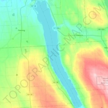
Nom : Carte topographique Owasco Lake, altitude, relief.
Altitude moyenne : 305 m
Altitude minimum : 208 m
Altitude maximum : 492 m
Owasco Lake is 11.1 miles (17.9 km) long, with a maximum width of 1.3 miles (2.1 km). The lake reaches a maximum depth of 177 feet (54 m) and has a surface elevation of 712 feet (217 m) above sea level, controlled by a dam on the lake's outlet. The lake has a volume of 212 billion US gallons (800,000,000 m3), and drains a watershed of 208 square miles (540 km2).
Autres cartes topographiques
Cliquez sur une carte pour visualiser sa topographie, son altitude et son relief.
Gregory Landing
United States > New York > Cayuga County > Town of Niles
Gregory Landing, Town of Niles, Cayuga County, New York, United States
Altitude moyenne : 356 m
New Hope
United States > New York > Cayuga County > Town of Niles
New Hope, Town of Niles, Cayuga County, New York, United States
Altitude moyenne : 446 m
Omro
United States > New York > Cayuga County > Town of Niles
Omro, Town of Niles, Cayuga County, New York, 13118, United States
Altitude moyenne : 424 m
Globe Hotel Corners
United States > New York > Cayuga County > Town of Niles
Globe Hotel Corners, Town of Niles, Cayuga County, New York, United States
Altitude moyenne : 429 m
Austin
United States > New York > Cayuga County > Town of Niles
Austin, Town of Niles, Cayuga County, New York, United States
Altitude moyenne : 340 m
Partello Corners
United States > New York > Cayuga County > Town of Niles
Partello Corners, Town of Niles, Cayuga County, New York, United States
Altitude moyenne : 423 m
Kelloggsville
United States > New York > Cayuga County > Town of Niles
Kelloggsville, Town of Niles, Cayuga County, New York, United States
Altitude moyenne : 442 m