
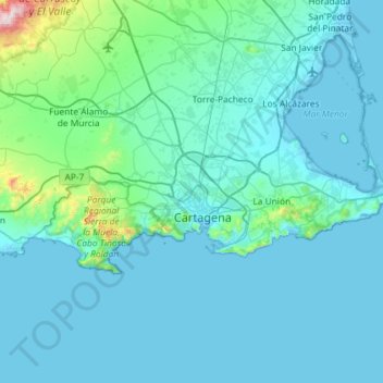
Carte topographique Cartagena
Carte interactive
Cliquez sur la carte pour afficher l’altitude.
À propos de cette carte
Nom : Carte topographique Cartagena, altitude, relief.
Altitude moyenne : 70 m
Altitude minimum : -5 m
Altitude maximum : 1’060 m
Cartagena's coastal mountains have one of the highest levels of botanical biodiversity on the Iberian Peninsula. A number of surprising Ibero-African species, which are only found in southern Spain (mostly in the provinces of Murcia and Almería) and North Africa. Among these, there stands out Tetraclinis articulata or Sandarac (sabina mora o ciprés de Cartagena—Cartagena's cypress in Spanish) native to Morocco, Algeria, Tunisia, Malta, and Cartagena, growing at relatively low altitudes in a hot, dry Mediterranean woodland. Some species are seriously endangered like the siempreviva de Cartagena (Limonium carthaginense), the rabogato del Mar Menor (Sideritis marmironensis), the zamarrilla de Cartagena (Teucrium carthaginense), the manzanilla de Escombreras (Anthemis chrysantha), the garbancillo de Tallante (Astragalus nitidiflorus) and the jara de Cartagena Cistus heterophyllus carthaginensis).
Autres cartes topographiques
Cliquez sur une carte pour visualiser sa topographie, son altitude et son relief.
Monte Sacro
Spain > Region of Murcia > Campo de Cartagena y Mar Menor > Cartagena
Monte Sacro, Cartagena, Campo de Cartagena y Mar Menor, Region of Murcia, 30203, Spain
Altitude moyenne : 12 m
San Pedro del Pinatar
Spain > Region of Murcia > Campo de Cartagena y Mar Menor
San Pedro del Pinatar, Campo de Cartagena y Mar Menor, Region of Murcia, 30740, Spain
Altitude moyenne : 17 m
Los Alcázares
Spain > Region of Murcia > Campo de Cartagena y Mar Menor
Los Alcázares, Campo de Cartagena y Mar Menor, Region of Murcia, 30710, Spain
Altitude moyenne : 9 m
San Javier
Spain > Region of Murcia > Campo de Cartagena y Mar Menor
San Javier, Campo de Cartagena y Mar Menor, Region of Murcia, Spain
Altitude moyenne : 29 m
Fuente Álamo de Murcia
Spain > Region of Murcia > Campo de Cartagena y Mar Menor
Fuente Álamo de Murcia, Campo de Cartagena y Mar Menor, Region of Murcia, Spain
Altitude moyenne : 216 m