
Carte topographique Stammbach
Carte interactive
Cliquez sur la carte pour afficher l’altitude.
À propos de cette carte
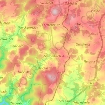
Nom : Carte topographique Stammbach, altitude, relief.
Lieu : Stammbach, Landkreis Hof, Bayern, Deutschland (50.11525 11.64225 50.18106 11.76335)
Altitude moyenne : 564 m
Altitude minimum : 419 m
Altitude maximum : 669 m
Autres cartes topographiques
Cliquez sur une carte pour visualiser sa topographie, son altitude et son relief.
Köditz
Deutschland > Bayern > Landkreis Hof
Köditz, Landkreis Hof, Bayern, 95189, Deutschland
Altitude moyenne : 543 m
Wurlitz
Deutschland > Bayern > Landkreis Hof > Rehau
Wurlitz, Rehau, Landkreis Hof, Bayern, 95111, Deutschland
Altitude moyenne : 544 m