
Carte topographique Kharga
Carte interactive
Cliquez sur la carte pour afficher l’altitude.
À propos de cette carte
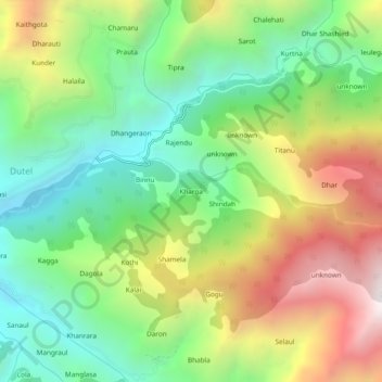
Nom : Carte topographique Kharga, altitude, relief.
Lieu : Kharga, Chamba, Chamba District, Himachal Pradesh, India (32.57402 76.23345 32.61402 76.27345)
Altitude moyenne : 1’840 m
Altitude minimum : 1’262 m
Altitude maximum : 2’725 m
Autres cartes topographiques
Cliquez sur une carte pour visualiser sa topographie, son altitude et son relief.
Gond
India > Himachal Pradesh > Chamba > Gond
Gond, Chamba, Himachal Pradesh, 176314, India
Altitude moyenne : 1’842 m