
Carte topographique Rathsweiler
Carte interactive
Cliquez sur la carte pour afficher l’altitude.
À propos de cette carte
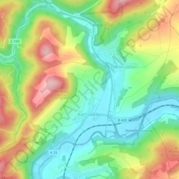
Nom : Carte topographique Rathsweiler, altitude, relief.
Altitude moyenne : 268 m
Altitude minimum : 183 m
Altitude maximum : 395 m
The municipality lies near the river Glan in the Western Palatinate. Rathsweiler lies in the Glan valley near where the Steinalb empties into the Glan at an elevation of 187 m above sea level and at the foot of the Hohlbusch (403 m) and the Nollkopf (402 m). Within the village itself, elevations range from 195 to 220 m above sea level. The municipal area measures 425 ha, of which 116 ha is wooded and roughly 10 ha is settled. In 1987, 160 ha of land was sold to the Federal Republic and it now belongs to the Baumholder troop drilling ground.
Autres cartes topographiques
Cliquez sur une carte pour visualiser sa topographie, son altitude et son relief.
Kusel
Germany > Rhineland-Palatinate > Landkreis Kusel
Kusel, Kusel-Altenglan, Landkreis Kusel, Rhineland-Palatinate, Germany
Altitude moyenne : 311 m