
Carte topographique Buckie
Cliquez sur la carte pour afficher l’altitude.
Buckie
Robert Gordon's map Aberdeen, Banf, Murrey &c. to Inverness: [and] Fra the north water to Ross, which is dated at some time between 1636 and 1652, shows Buckie in its own right as a community some small distance from the coast with the community of Freuchny sitting nearer the shore to the north. Robert Gordon and Joan Blaeu's Duo Vicecomitatus Aberdonia & Banfia, una cum Regionibus & terrarum tractibus sub iis comprehensis published in Amsterdam 1654 clearly shows Buckie and Freuchny with the addition of Nether Buckie. James Robertson's Topographical and military map of the counties of Aberdeen, Banff and Kincardine, London, 1822 seems geographically inaccurate in its relative positioning of Buckie, Nether Buckie and Freuchny, but is significant in that the new label of Rotten Slough is given equal importance in terms of size of community with Buckie; however, in Thomson’s Atlas of Scotland, Edinburgh, 1832 Rotten Slough is fairly unimportant by size so one of these two reference publications is distorted, probably the former. This community, which would later come to be known as Portessie, was reportedly formed when "Porteasie.....became a fishing station in 1727, when 5 houses were built by the proprietor of Rannes for the accommodation of the original fishers from Findhorn" and the 1731 Rathven Session Minutes shows that Rotten Slough already has a population of 40 with ten households and subsequent minutes show the community growing until the 1791 entry records 177 souls in 44 households.
À propos de cette carte
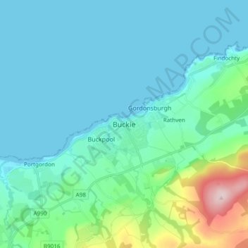
Nom : Carte topographique Buckie, altitude, relief.
Lieu : Buckie, Moray, Scotland, AB56 1AH, United Kingdom (57.63633 -3.00489 57.71633 -2.92489)
Altitude moyenne : 43 m
Altitude minimum : -1 m
Altitude maximum : 277 m
Autres cartes topographiques
Cliquez sur une carte pour visualiser sa topographie, son altitude et son relief.
Fochabers
United Kingdom > Scotland > Moray
The present village owes its existence to Alexander Gordon, 4th Duke of Gordon (1743–1827). During the late eighteenth century, during the Scottish Enlightenment, it was fashionable for landowners to found new towns and villages; these can be recognised all over Scotland, because unlike their predecessors…
Altitude moyenne : 59 m