
Carte topographique Village of Mohawk
Carte interactive
Cliquez sur la carte pour afficher l’altitude.
À propos de cette carte
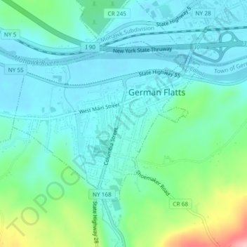
Nom : Carte topographique Village of Mohawk, altitude, relief.
Altitude moyenne : 148 m
Altitude minimum : 114 m
Altitude maximum : 270 m
Autres cartes topographiques
Cliquez sur une carte pour visualiser sa topographie, son altitude et son relief.
Dennison Corners
United States > New York > Herkimer County > Town of German Flatts
Dennison Corners, Town of German Flatts, Herkimer County, New York, 13407, United States
Altitude moyenne : 404 m
Edicks
United States > New York > Herkimer County > Town of German Flatts
Edicks, Town of German Flatts, Herkimer County, New York, United States
Altitude moyenne : 355 m
South Ilion
United States > New York > Herkimer County > Town of German Flatts
South Ilion, Town of German Flatts, Herkimer County, New York, United States
Altitude moyenne : 239 m
Days Rock
United States > New York > Herkimer County > Town of German Flatts
Days Rock, Town of German Flatts, Herkimer County, New York, 13407, United States
Altitude moyenne : 317 m
Fort Herkimer
United States > New York > Herkimer County > Town of German Flatts
Fort Herkimer, Town of German Flatts, Herkimer County, New York, 13350, United States
Altitude moyenne : 177 m
Village of Ilion
United States > New York > Herkimer County > Town of German Flatts
Village of Ilion, Town of German Flatts, Herkimer County, New York, 13357, United States
Altitude moyenne : 151 m