
Carte topographique Laramie
Carte interactive
Cliquez sur la carte pour afficher l’altitude.
À propos de cette carte
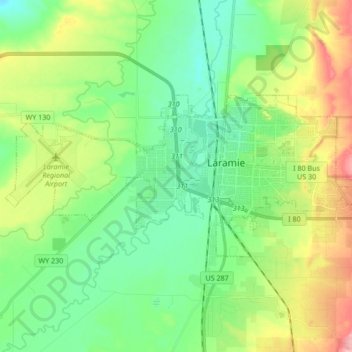
Nom : Carte topographique Laramie, altitude, relief.
Lieu : Laramie, Albany County, Wyoming, United States (41.27742 -105.69729 41.33581 -105.52819)
Altitude moyenne : 2’219 m
Altitude minimum : 2’166 m
Altitude maximum : 2’462 m
Laramie (/ˈlærəmi/) is a city in and the county seat of Albany County, Wyoming, United States, known for its high elevation at 7,200 feet (2,200 m), railroad history, and as the higher-education center for the state of Wyoming. The population was estimated 31,407 in 2020, making it the 4th most populous city in Wyoming. Located on the Laramie River in southeastern Wyoming, the city is west of Cheyenne and 25 miles (40 km) north of the Colorado state line, at the junction of Interstate 80 and U.S. Route 287.
Autres cartes topographiques
Cliquez sur une carte pour visualiser sa topographie, son altitude et son relief.
Chalk Bluff
United States > Wyoming > Albany County
Chalk Bluff, Albany County, Wyoming, United States
Altitude moyenne : 2’153 m
Laramie
United States > Wyoming > Albany County > Laramie
Laramie, Albany County, Wyoming, 82070, United States
Altitude moyenne : 2’299 m