
Carte topographique Cooks
Carte interactive
Cliquez sur la carte pour afficher l’altitude.
À propos de cette carte
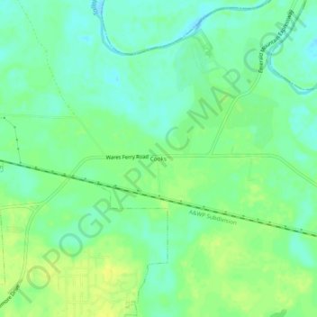
Nom : Carte topographique Cooks, altitude, relief.
Lieu : Cooks, Montgomery County, Alabama, 36124, United States (32.39153 -86.16663 32.43153 -86.12663)
Altitude moyenne : 51 m
Altitude minimum : 42 m
Altitude maximum : 61 m
Autres cartes topographiques
Cliquez sur une carte pour visualiser sa topographie, son altitude et son relief.
Pike Road
United States > Alabama > Montgomery County
Pike Road, Montgomery County, Alabama, 36064, United States
Altitude moyenne : 73 m
Cloverland
United States > Alabama > Montgomery County > Montgomery
Cloverland, Montgomery, Montgomery County, Alabama, 36104, United States
Altitude moyenne : 67 m
Montgomery
United States > Alabama > Montgomery County
Montgomery, Montgomery County, Alabama, United States
Altitude moyenne : 64 m
Johnstown East
United States > Alabama > Montgomery County > Montgomery
Johnstown East, Montgomery, Montgomery County, Alabama, 36109, United States
Altitude moyenne : 73 m
Flatwood
United States > Alabama > Montgomery County
Flatwood, Montgomery County, Alabama, 36110, United States
Altitude moyenne : 49 m
Landmarks
United States > Alabama > Montgomery County > Montgomery > Landmarks
Landmarks, Montgomery, Montgomery County, Alabama, 36119, United States
Altitude moyenne : 72 m
Lapine
United States > Alabama > Montgomery County
Lapine, Montgomery County, Alabama, United States
Altitude moyenne : 139 m