
Carte topographique Hay Island
Carte interactive
Cliquez sur la carte pour afficher l’altitude.
À propos de cette carte
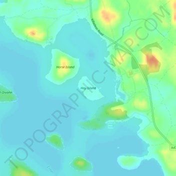
Nom : Carte topographique Hay Island, altitude, relief.
Altitude moyenne : 49 m
Altitude minimum : 40 m
Altitude maximum : 79 m
Autres cartes topographiques
Cliquez sur une carte pour visualiser sa topographie, son altitude et son relief.
Enniskillen
United Kingdom > Northern Ireland > County Fermanagh
Enniskillen, County Fermanagh, Ulster, Northern Ireland, BT74 7DH, United Kingdom
Altitude moyenne : 66 m