Géolocaliser

Carte topographique Wildcat Mountain

Carte interactive

Cliquez sur la carte pour afficher l’altitude.

À propos de cette carte

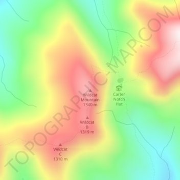
Nom : Carte topographique Wildcat Mountain, altitude, relief.

Lieu : Wildcat Mountain, Coös County, New Hampshire, United States (44.25890 -71.20151 44.25900 -71.20141)

Altitude moyenne : 1’055 m

Altitude minimum : 738 m

Altitude maximum : 1’406 m

Wildcat Mountain has five summits — A, B, C, D, and E — along Wildcat Ridge, which curves two miles (3 km) to the south and west. Both A, at 4,422 feet (1,348 m), and D, at 4,062 feet (1,238 m), are considered "four-thousand footers". B, with an elevation of 4,305 feet (1,312 m), and C, at 4,285 feet (1,306 m), lack the topographic prominence to be considered more than subpeaks of Wildcat A. Likewise, the E peak, at 4,046 feet (1,233 m), is considered to be a subpeak of the higher D peak (the E peak was formerly believed to be the higher of the two, and used to appear on the official list of four-thousand footers, but current topographic maps reveal the D peak to be the higher summit).

Wikipedia (CC-BY-SA 3.0)

Autres cartes topographiques

Cliquez sur une carte pour visualiser sa topographie, son altitude et son relief.

Kidderville

United States > New Hampshire > Coos County > Colebrook

Kidderville, Colebrook, Coös County, New Hampshire, United States

Altitude moyenne : 472 m

Dixville

United States > New Hampshire > Coos County

Dixville, Coös County, New Hampshire, United States

Altitude moyenne : 635 m

Mount Washington

United States > New Hampshire > Coos County

Mount Washington, Coös County, New Hampshire, United States

Altitude moyenne : 1’568 m

Northumberland

United States > New Hampshire > Coos County

Northumberland, Coös County, New Hampshire, United States

Altitude moyenne : 383 m

Stark

United States > New Hampshire > Coos County

Stark, Coös County, New Hampshire, United States

Altitude moyenne : 526 m

Shelburne

United States > New Hampshire > Coos County

Shelburne, Coös County, New Hampshire, United States

Altitude moyenne : 467 m

Groveton

United States > New Hampshire > Coos County

Groveton, Northumberland, Coös County, New Hampshire, United States

Altitude moyenne : 304 m

Columbia

United States > New Hampshire > Coos County

Columbia, Coös County, New Hampshire, United States

Altitude moyenne : 553 m

Dummer

United States > New Hampshire > Coos County

Dummer, Coös County, New Hampshire, United States

Altitude moyenne : 419 m

Twin Mountain

United States > New Hampshire > Coos County > Carroll

Twin Mountain, Carroll, Coös County, New Hampshire, 03595, United States

Altitude moyenne : 490 m

Pinkham Notch

United States > New Hampshire > Coos County

Pinkham Notch, Pinkham's Grant, Coös County, New Hampshire, United States

Altitude moyenne : 767 m

Milan

United States > New Hampshire > Coos County

Milan, Coös County, New Hampshire, 03588, United States

Altitude moyenne : 448 m

Stratford

United States > New Hampshire > Coos County

Stratford, Coös County, New Hampshire, 03590, United States

Altitude moyenne : 497 m

Castellated Ridge

United States > New Hampshire > Coos County

Castellated Ridge, Low and Burbank's Grant, Coös County, New Hampshire, United States

Altitude moyenne : 1’080 m

Lost Nation

United States > New Hampshire > Coos County > Northumberland

Lost Nation, Northumberland, Coös County, New Hampshire, United States

Altitude moyenne : 363 m

North Stratford

United States > New Hampshire > Coos County

North Stratford, Stratford, Coös County, New Hampshire, 03590, United States

Altitude moyenne : 340 m

Colebrook

United States > New Hampshire > Coos County

Colebrook, Coös County, New Hampshire, 03576, United States

Altitude moyenne : 476 m

Whitefield

United States > New Hampshire > Coos County

Whitefield, Coös County, New Hampshire, United States

Altitude moyenne : 365 m

Gorham

United States > New Hampshire > Coos County

Gorham, Coös County, New Hampshire, 03581, United States

Altitude moyenne : 477 m

Upper Kidderville

United States > New Hampshire > Coos County > Colebrook

Upper Kidderville, Colebrook, Coos County, New Hampshire, United States

Altitude moyenne : 478 m

Pittsburg

United States > New Hampshire > Coos County

Pittsburg, Coös County, New Hampshire, United States

Altitude moyenne : 522 m

Castle Mountain

United States > New Hampshire > Coos County

Castle Mountain, Coos County, New Hampshire, United States

Altitude moyenne : 937 m

Carroll

United States > New Hampshire > Coos County

Carroll, Coös County, New Hampshire, United States

Altitude moyenne : 562 m

Lancaster

United States > New Hampshire > Coos County

Lancaster, Coös County, New Hampshire, 03584, United States

Altitude moyenne : 371 m

Bretton Woods

United States > New Hampshire > Coos County > Carroll

Bretton Woods, Carroll, Coös County, New Hampshire, 03575, United States

Altitude moyenne : 577 m

Clarksville

United States > New Hampshire > Coos County

Clarksville, Coös County, New Hampshire, United States

Altitude moyenne : 570 m

Mount Crescent

United States > New Hampshire > Coos County

Mount Crescent, Coos County, New Hampshire, 03593, United States

Altitude moyenne : 748 m

Triple Falls

United States > New Hampshire > Coos County > Gorham

Triple Falls, Gorham, Coos County, New Hampshire, 03593, United States

Altitude moyenne : 558 m

Randolph

United States > New Hampshire > Coos County

Randolph, Coös County, New Hampshire, 03593, United States

Altitude moyenne : 594 m

LIttle Diamond Pond

United States > New Hampshire > Coos County > Stewartstown

LIttle Diamond Pond, Stewartstown, Coos County, New Hampshire, United States

Altitude moyenne : 693 m

Jefferson Highland

United States > New Hampshire > Coos County > Jefferson > Jefferson Highland

Jefferson Highland, Jefferson, Coos County, New Hampshire, 03583, United States

Altitude moyenne : 451 m

Jefferson

United States > New Hampshire > Coos County

Jefferson, Coös County, New Hampshire, 03583, United States

Altitude moyenne : 493 m

Dixville Notch

United States > New Hampshire > Coos County

Dixville Notch, Coos County, New Hampshire, United States

Altitude moyenne : 655 m

Stewartstown

United States > New Hampshire > Coos County

Stewartstown, Coös County, New Hampshire, 03597, United States

Altitude moyenne : 485 m

Dalton

United States > New Hampshire > Coos County

Dalton, Coös County, New Hampshire, United States

Altitude moyenne : 375 m

Errol

United States > New Hampshire > Coos County

Errol, Coös County, New Hampshire, United States

Altitude moyenne : 453 m

Mount Eisenhower

United States > New Hampshire > Coos County

Mount Eisenhower, Coos County, New Hampshire, 03589, United States

Altitude moyenne : 1’142 m