
Carte topographique Tonsel
Carte interactive
Cliquez sur la carte pour afficher l’altitude.
À propos de cette carte
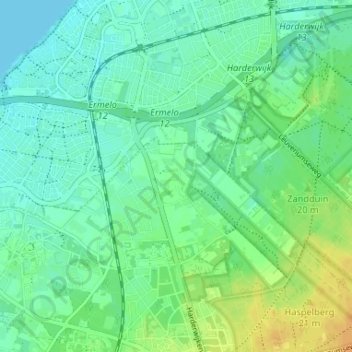
Nom : Carte topographique Tonsel, altitude, relief.
Lieu : Tonsel, Ermelo, Gelderland, Nederland, 3852 LD, Nederland (52.30307 5.60677 52.34307 5.64677)
Altitude moyenne : 9 m
Altitude minimum : -3 m
Altitude maximum : 27 m
Autres cartes topographiques
Cliquez sur une carte pour visualiser sa topographie, son altitude et son relief.
Houtdorp
Nederland > Gelderland > Ermelo
Houtdorp, Ermelo, Gelderland, Nederland, 3852 NJ, Nederland
Altitude moyenne : 40 m
Stakenberg
Nederland > Gelderland > Ermelo
Stakenberg, Ermelo, Gelderland, Nederland, 3852 PR, Nederland
Altitude moyenne : 25 m
Cyriasische Veld
Nederland > Gelderland > Ermelo
Cyriasische Veld, Harderwijk, Ermelo, Gelderland, Nederland
Altitude moyenne : 18 m
Speuld
Nederland > Gelderland > Ermelo
Speuld, Ermelo, Gelderland, Nederland, 3852 NL, Nederland
Altitude moyenne : 35 m
Telgt
Nederland > Gelderland > Ermelo
Telgt, Ermelo, Gelderland, Nederland, 3853 NK, Nederland
Altitude moyenne : 6 m
Staverden
Nederland > Gelderland > Ermelo
Staverden, Ermelo, Gelderland, Nederland, 3852 NV, Nederland
Altitude moyenne : 23 m
Houtdorperveld
Nederland > Gelderland > Ermelo
Houtdorperveld, Speulderveld, Ermelo, Gelderland, Nederland, 3852NZ, Nederland
Altitude moyenne : 27 m
Leuvenum
Nederland > Gelderland > Ermelo
Leuvenum, Ermelo, Gelderland, Nederland, 3852 PT, Nederland
Altitude moyenne : 21 m