
Faire un don
Équipez-vous pour votre prochaine aventure :
En tant que Partenaire Amazon, ce site perçoit une commission sur les achats éligibles sans surcoût pour vous.
Carte topographique Central Point
Cliquez sur la carte pour afficher l’altitude.
Faire un don
Équipez-vous pour votre prochaine aventure :
En tant que Partenaire Amazon, ce site perçoit une commission sur les achats éligibles sans surcoût pour vous.
Central Point
The city lies at an elevation of about 1,272 feet (388 m) along Oregon Highway 99 and Interstate 5 northwest of Medford. Jacksonville is to the south and Gold Hill to the northwest. The Central Oregon and Pacific Railroad passes through Central Point.
Faire un don
Équipez-vous pour votre prochaine aventure :
En tant que Partenaire Amazon, ce site perçoit une commission sur les achats éligibles sans surcoût pour vous.
À propos de cette carte
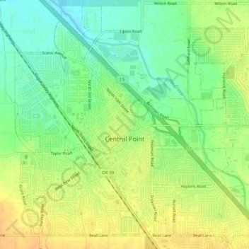
Nom : Carte topographique Central Point, altitude, relief.
Altitude moyenne : 385 m
Altitude minimum : 368 m
Altitude maximum : 401 m
Faire un don
Équipez-vous pour votre prochaine aventure :
En tant que Partenaire Amazon, ce site perçoit une commission sur les achats éligibles sans surcoût pour vous.