
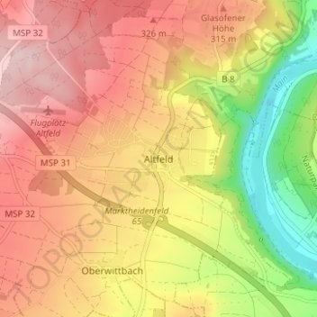
Carte topographique Altfeld
Carte interactive
Cliquez sur la carte pour afficher l’altitude.
À propos de cette carte
Nom : Carte topographique Altfeld, altitude, relief.
Altitude moyenne : 271 m
Altitude minimum : 133 m
Altitude maximum : 373 m
Autres cartes topographiques
Cliquez sur une carte pour visualiser sa topographie, son altitude et son relief.
Eichenfürst
Deutschland > Bayern > Landkreis Main-Spessart > Marktheidenfeld > Altfeld
Eichenfürst, Glasofen, Altfeld, Marktheidenfeld, Landkreis Main-Spessart, Bayern, 97828, Deutschland
Altitude moyenne : 253 m
Glasofen
Deutschland > Bayern > Landkreis Main-Spessart > Marktheidenfeld
Glasofen, Marktheidenfeld, Landkreis Main-Spessart, Bayern, Deutschland
Altitude moyenne : 254 m
Marienbrunn
Deutschland > Bayern > Landkreis Main-Spessart > Marktheidenfeld
Marienbrunn, Marktheidenfeld, Landkreis Main-Spessart, Bayern, Deutschland
Altitude moyenne : 234 m
Dillberg
Deutschland > Bayern > Landkreis Main-Spessart > Marktheidenfeld
Dillberg, Marktheidenfeld, Landkreis Main-Spessart, Bayern, 97828, Deutschland
Altitude moyenne : 203 m