
Carte topographique Half Dome
Carte interactive
Cliquez sur la carte pour afficher l’altitude.
À propos de cette carte
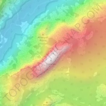
Nom : Carte topographique Half Dome, altitude, relief.
Lieu : Half Dome, Mariposa County, California, United States (37.74595 -119.53330 37.74605 -119.53320)
Altitude moyenne : 1’887 m
Altitude minimum : 1’241 m
Altitude maximum : 2’693 m
The Half Dome Cable Route hike runs from the valley floor to the top of the dome in 8.2 mi (13 km) (via the Mist Trail), with 4,800 ft (1,460 m) of elevation gain. The length and difficulty of the trail used to keep it less crowded than other park trails, but in recent years the trail traffic has grown to as many as 800 people a day. The hike can be done from the valley floor in a single long day, but many people break it up by camping overnight in Little Yosemite Valley. The trail climbs past Vernal Fall and Nevada Fall, then continues into Little Yosemite Valley, then north to the base of the northeast ridge of Half Dome itself.
Autres cartes topographiques
Cliquez sur une carte pour visualiser sa topographie, son altitude et son relief.
Incline
United States > California > Mariposa County
Incline, Mariposa County, California, United States
Altitude moyenne : 795 m
Bear Valley
United States > California > Mariposa County
Bear Valley, Mariposa County, California, United States
Altitude moyenne : 729 m
Smith Peak
United States > California > Mariposa County
Smith Peak, Mariposa County, California, United States
Altitude moyenne : 1’016 m
Guadalupe Mountains
United States > California > Mariposa County
Guadalupe Mountains, Mariposa County, California, United States
Altitude moyenne : 714 m
Mount Bullion
United States > California > Mariposa County
Mount Bullion, Mariposa County, California, United States
Altitude moyenne : 714 m
PO box 577
United States > California > Mariposa County
PO box 577, John Muir Trail, Mariposa County, CAL Fire Southern Region, California, 95389, United States
Altitude moyenne : 1’967 m
Hornitos
United States > California > Mariposa County
Hornitos, Mariposa County, California, 95325, United States
Altitude moyenne : 297 m
Mariposa Grove
United States > California > Mariposa County
Mariposa Grove, Mariposa County, California, United States
Altitude moyenne : 1’809 m
Crane Flat
United States > California > Mariposa County
Crane Flat, Mariposa County, California, United States
Altitude moyenne : 1’906 m
Yosemite Village
United States > California > Mariposa County
Yosemite Village, Mariposa County, California, 95389, United States
Altitude moyenne : 1’680 m
Glacier Point
United States > California > Mariposa County > Curry Village
Glacier Point, PO box 577, Four Mile Trail, Curry Village, Mariposa County, CAL Fire Southern Region, California, 95389, United States
Altitude moyenne : 1’775 m
Wawona
United States > California > Mariposa County
Wawona, Mariposa County, California, United States
Altitude moyenne : 1’334 m