
Carte topographique El Mehara
Carte interactive
Cliquez sur la carte pour afficher l’altitude.
À propos de cette carte
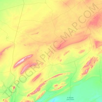
Nom : Carte topographique El Mehara, altitude, relief.
Lieu : El Mehara, daïra Chellala, El Bayadh, 32002, Algérie (32.86875 -0.01786 33.67074 0.92339)
Altitude moyenne : 1’194 m
Altitude minimum : 855 m
Altitude maximum : 1’775 m
Autres cartes topographiques
Cliquez sur une carte pour visualiser sa topographie, son altitude et son relief.
Chellala
Algérie > El Bayadh > daïra Chellala
Chellala, daïra Chellala, El Bayadh, Algérie
Altitude moyenne : 1’156 m
Chellala Dahrania
Algérie > El Bayadh > daïra Chellala > Chellala
Chellala Dahrania, Chellala, daïra Chellala, El Bayadh, Algérie
Altitude moyenne : 1’132 m