
Carte topographique Salta
Carte interactive
Cliquez sur la carte pour afficher l’altitude.
À propos de cette carte
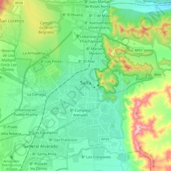
Nom : Carte topographique Salta, altitude, relief.
Lieu : Salta, Municipio de Salta, Capital, Salta, Argentina (-24.87349 -65.47912 -24.71081 -65.34063)
Altitude moyenne : 1’270 m
Altitude minimum : 1’100 m
Altitude maximum : 1’762 m
Salta has a subtropical highland climate (Cwb, according to the Köppen climate classification), and it is characterized by pleasant weather year-round. Located in the subtropical north, but at an altitude of 1,200 metres, Salta enjoys 4 distinct seasons: summers are warm with frequent thunderstorms, with daytime highs around 26 to 28 °C (78.8 to 82.4 °F) and pleasant, refreshing nights around 15 or 16 °C (59 or 61 °F). Fall brings dry weather, pleasant days at around 22 °C (71.6 °F) and mild nights at around 10 °C (50.0 °F). By winter, the dryness is extreme, with very few rain episodes. Nights are cool at 3 °C (37.4 °F) on average, but daytime heating allows for high temperatures of 19 °C (66.2 °F). Snow is rare and frost is quite common, with temperatures reaching down to −7 °C (19.4 °F) during the coldest nights. Spring brings sunny weather with warm days and mild nights: days range from 25 to 28 °C (77.0 to 82.4 °F) with nights between 10 to 14 °C (50.0 to 57.2 °F). Salta's winters are rather warm for its elevation and far inland position for a location being just outside the tropics.
Autres cartes topographiques
Cliquez sur une carte pour visualiser sa topographie, son altitude et son relief.
Municipio de Las Lajitas
Municipio de Las Lajitas, Anta, Salta, Argentina
Altitude moyenne : 548 m
Campo Durán
Argentina > Salta > Municipio de Aguaray
Campo Durán, Municipio de Aguaray, General San Martín, Salta, Argentina
Altitude moyenne : 518 m
Salar del Rincón
Salar del Rincón, Los Andes, Salta, Argentina
Altitude moyenne : 3’941 m
San Lorenzo
San Lorenzo, Municipio de San Lorenzo, Capital, Salta, Argentina
Altitude moyenne : 1’357 m
Nevado de Quehuar
Argentina > Salta > Municipio de San Antonio de los Cobres
Nevado de Quehuar, Municipio de San Antonio de los Cobres, Los Andes, Salta, Argentina
Altitude moyenne : 5’737 m
Quemado
Argentina > Salta > Municipio de La Poma
Quemado, Municipio de La Poma, Departemento La Poma, Salta, Argentina
Altitude moyenne : 5’769 m
Joaquín Victor González
Argentina > Salta > Joaquín Victor González
Joaquín Victor González, Municipio de Joaquín V. González, Anta, Salta, 4448, Argentina
Altitude moyenne : 378 m
Municipio de General Mosconi
Municipio de General Mosconi, General San Martín, Salta, Argentina
Altitude moyenne : 588 m