
Carte topographique Ballinamore
Carte interactive
Cliquez sur la carte pour afficher l’altitude.
À propos de cette carte
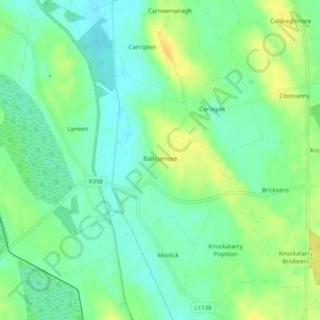
Nom : Carte topographique Ballinamore, altitude, relief.
Altitude moyenne : 54 m
Altitude minimum : 43 m
Altitude maximum : 68 m
Autres cartes topographiques
Cliquez sur une carte pour visualiser sa topographie, son altitude et son relief.
Finns
Finns, Doory ED, Ballymahon Municipal District, County Longford, Leinster, Ireland
Altitude moyenne : 85 m
Edgeworthstown
Ireland > County Longford > Edgeworthstown
Edgeworthstown, Ballymahon Municipal District, County Longford, Leinster, N39 AH64, Ireland
Altitude moyenne : 95 m
Aghadowry
Ireland > County Longford > Aghadowry
Aghadowry, Ballinamuck East ED, Granard Municipal District, County Longford, Leinster, Ireland
Altitude moyenne : 161 m