
Faire un don
Équipez-vous pour votre prochaine aventure :
En tant que Partenaire Amazon, ce site perçoit une commission sur les achats éligibles sans surcoût pour vous.
Carte topographique Trinidad
Cliquez sur la carte pour afficher l’altitude.
Faire un don
Équipez-vous pour votre prochaine aventure :
En tant que Partenaire Amazon, ce site perçoit une commission sur les achats éligibles sans surcoût pour vous.
Trinidad
Trinidad (Spanish for "Trinity"; Yurok: Chuerey) is a seaside city in Humboldt County, located on the Pacific Ocean 8 miles (13 km) north of the Arcata-Eureka Airport and 15 miles (24 km) north of the college town of Arcata. Trinidad is noted for its coastline with ten public beaches and offshore rocks, part of the California Coastal National Monument, of which Trinidad is a Gateway City. Fishing operations related to Trinidad Harbor are vital to both local tourism and commercial fishery interests in the region. Situated at an elevation of 174 feet (53 m) above its own North Coast harbor, Trinidad is one of California's smallest incorporated cities by population (367 residents in 2010, up from 311 residents in 2000).
Faire un don
Équipez-vous pour votre prochaine aventure :
En tant que Partenaire Amazon, ce site perçoit une commission sur les achats éligibles sans surcoût pour vous.
À propos de cette carte
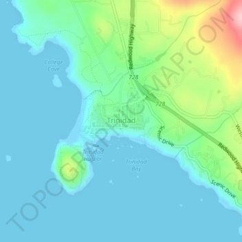
Nom : Carte topographique Trinidad, altitude, relief.
Altitude moyenne : 38 m
Altitude minimum : -2 m
Altitude maximum : 191 m
Faire un don
Équipez-vous pour votre prochaine aventure :
En tant que Partenaire Amazon, ce site perçoit une commission sur les achats éligibles sans surcoût pour vous.
Autres cartes topographiques
Cliquez sur une carte pour visualiser sa topographie, son altitude et son relief.
Eureka
United States > California > Humboldt County
Eureka, located along Humboldt Bay in Northern California, has a diverse and varied topography. The city itself is situated at relatively low elevations, with the bay’s narrow point serving as a key feature in the landscape. Its average elevation is around 50 feet (15 meters), and the terrain gently rises…
Altitude moyenne : 15 m
Fieldbrook
United States > California > Humboldt County
Fieldbrook (formerly Bokman's Prairie and Buckman's Prairie) is a census-designated place in Humboldt County, California. It is located 7 miles (11 km) north-east of Arcata, at an elevation of 203 feet (62 m). The population was 827 at the 2020 census.
Altitude moyenne : 254 m
Shelter Cove
United States > California > Humboldt County > Shelter Cove
Shelter Cove is a census-designated place in Humboldt County, California. It lies at an elevation of 138 feet (42 m). Shelter Cove is on California's Lost Coast where the King Range meets the Pacific Ocean. A nine-hole golf course surrounds the one-runway Shelter Cove Airport at the center of Shelter Cove's…
Altitude moyenne : 260 m
Faire un don
Équipez-vous pour votre prochaine aventure :
En tant que Partenaire Amazon, ce site perçoit une commission sur les achats éligibles sans surcoût pour vous.
Weott
United States > California > Humboldt County > Weott
Weott is an unincorporated community in Humboldt County, California. It is located 233 miles (375 km) north of San Francisco and 25 miles (40 km) due east of the Pacific Ocean. Lower Weott is situated at an elevation of 330 feet (100 m) along the Avenue of the Giants scenic highway and in the flood plain of…
Altitude moyenne : 190 m
Faire un don
Équipez-vous pour votre prochaine aventure :
En tant que Partenaire Amazon, ce site perçoit une commission sur les achats éligibles sans surcoût pour vous.
Garberville
United States > California > Humboldt County
Garberville is a census-designated place in Humboldt County, California. It is located on the South Fork of the Eel River 52 miles (84 km) south-southeast of Eureka, at an elevation of 535 feet (163 m). The population was 913 at the 2010 United States Census. It is approximately 200 miles (320 km) north of San…
Altitude moyenne : 198 m
Faire un don
Équipez-vous pour votre prochaine aventure :
En tant que Partenaire Amazon, ce site perçoit une commission sur les achats éligibles sans surcoût pour vous.
Arcata Community Forest
United States > California > Humboldt County > Arcata
Altitude moyenne : 152 m
Faire un don
Équipez-vous pour votre prochaine aventure :
En tant que Partenaire Amazon, ce site perçoit une commission sur les achats éligibles sans surcoût pour vous.
Trinidad
United States > California > Humboldt County
Trinidad (Spanish for "Trinity"; Yurok: Chuerey) is a seaside city in Humboldt County, located on the Pacific Ocean 8 miles (13 km) north of the Arcata-Eureka Airport and 15 miles (24 km) north of the college town of Arcata. Trinidad is noted for its coastline, with ten public beaches and offshore rocks, part…
Altitude moyenne : 38 m
Faire un don
Équipez-vous pour votre prochaine aventure :
En tant que Partenaire Amazon, ce site perçoit une commission sur les achats éligibles sans surcoût pour vous.
Weitchpec
United States > California > Humboldt County
Weitchpec (/ˈwɛtʃpɛk/ WETCH-pek; Karuk: Ansáfriik; Yurok: Wechpues, Wech) is an unincorporated village and CDP within the Yurok reservation in Humboldt County, California, United States. It is located 35 miles (56 km) northeast of Eureka, at an elevation of 361 feet (110 m). The ZIP Code is 95546.
Altitude moyenne : 354 m
Faire un don
Équipez-vous pour votre prochaine aventure :
En tant que Partenaire Amazon, ce site perçoit une commission sur les achats éligibles sans surcoût pour vous.
Humboldt Hill
United States > California > Humboldt County > Humboldt Hill
Humboldt Hill is a census-designated place (CDP) in Humboldt County, California, United States. Humboldt Hill rises to an elevation of 636 feet (194 m). The population was 3,498 at the 2020 census, up from 3,414 at the 2010 census. The area is in the 95503 zip code and part of unincorporated Eureka.
Altitude moyenne : 39 m
Blue Lake
United States > California > Humboldt County
Blue Lake (formerly, Scottsville) is a city in Humboldt County, California, United States. Blue Lake is located on the Mad River in a deep valley, 16 miles (26 km) northeast of Eureka, at an elevation of 131 feet (40 m). Its population is 1,208 as of the 2020 census, down from 1,253 from the 2010 census.
Altitude moyenne : 86 m
Eureka
United States > California > Humboldt County > Eureka
The city marina is on one of three islands at a narrow point on the 13-mile-long (21 km) bay and increases in elevation slightly as it spreads north, south, and especially to the east. The city gently encroaches at least two miles (3.2 km) eastward into primarily Redwood and Douglas-fir second growth forests.…
Altitude moyenne : 100 m
Faire un don
Équipez-vous pour votre prochaine aventure :
En tant que Partenaire Amazon, ce site perçoit une commission sur les achats éligibles sans surcoût pour vous.
Faire un don
Équipez-vous pour votre prochaine aventure :
En tant que Partenaire Amazon, ce site perçoit une commission sur les achats éligibles sans surcoût pour vous.
Trinidad
United States > California > Humboldt County
Trinidad (Spanish for "Trinity"; Yurok: Chuerey) is a seaside city in Humboldt County, located on the Pacific Ocean 8 miles (13 km) north of the Arcata-Eureka Airport and 15 miles (24 km) north of the college town of Arcata. Trinidad is noted for its coastline, with ten public beaches and offshore rocks, part…
Altitude moyenne : 38 m
Faire un don
Équipez-vous pour votre prochaine aventure :
En tant que Partenaire Amazon, ce site perçoit une commission sur les achats éligibles sans surcoût pour vous.
Eureka
United States > California > Humboldt County
The city marina is on one of three islands at a narrow point on the 13-mile-long (21 km) bay and increases in elevation slightly as it spreads north, south, and especially to the east. The city gently encroaches at least two miles (3.2 km) eastward into primarily Redwood and Douglas-fir second growth forests.…
Altitude moyenne : 15 m
Eureka
United States > California > Humboldt County
The city marina is on one of three islands at a narrow point on the 13-mile-long (21 km) bay and increases in elevation slightly as it spreads north, south, and especially to the east. The city gently encroaches at least two miles (3.2 km) eastward into primarily Redwood and Douglas-fir second growth forests.…
Altitude moyenne : 16 m
Faire un don
Équipez-vous pour votre prochaine aventure :
En tant que Partenaire Amazon, ce site perçoit une commission sur les achats éligibles sans surcoût pour vous.
Rio Dell
United States > California > Humboldt County
Rio Dell (Spanish: Río Dell, meaning "river," with English "dell," meaning small valley in a woodland) is a city in Humboldt County, California, United States. It is located on the west bank of the Eel River 1 mile (1.6 km) north of Scotia at an elevation of 161 feet (49 m). The population was 3,363 at the…
Altitude moyenne : 97 m
Blue Lake
United States > California > Humboldt County
Blue Lake (formerly Scottsville) is a city in Humboldt County, California, United States. Blue Lake is located on the Mad River in a deep valley, 16 miles (26 km) northeast of Eureka, at an elevation of 131 feet (40 m). Its population is 1,208 as of the 2020 census, down from 1,253 from the 2010 census.
Altitude moyenne : 86 m
Faire un don
Équipez-vous pour votre prochaine aventure :
En tant que Partenaire Amazon, ce site perçoit une commission sur les achats éligibles sans surcoût pour vous.
Faire un don
Équipez-vous pour votre prochaine aventure :
En tant que Partenaire Amazon, ce site perçoit une commission sur les achats éligibles sans surcoût pour vous.
Faire un don
Équipez-vous pour votre prochaine aventure :
En tant que Partenaire Amazon, ce site perçoit une commission sur les achats éligibles sans surcoût pour vous.
Faire un don
Équipez-vous pour votre prochaine aventure :
En tant que Partenaire Amazon, ce site perçoit une commission sur les achats éligibles sans surcoût pour vous.
Humboldt Redwoods State Park
United States > California > Humboldt County > Myers Flat
Altitude moyenne : 420 m
Faire un don
Équipez-vous pour votre prochaine aventure :
En tant que Partenaire Amazon, ce site perçoit une commission sur les achats éligibles sans surcoût pour vous.
Eureka
United States > California > Humboldt County
The city marina is on one of three islands at a narrow point on the 13-mile-long (21 km) bay and increases in elevation slightly as it spreads north, south, and especially to the east. The city gently encroaches at least two miles (3.2 km) eastward into primarily Redwood and Douglas-fir second growth forests.…
Altitude moyenne : 15 m
Faire un don
Équipez-vous pour votre prochaine aventure :
En tant que Partenaire Amazon, ce site perçoit une commission sur les achats éligibles sans surcoût pour vous.
Lone Star Junction
United States > California > Humboldt County > Lone Star Junction
Altitude moyenne : 614 m
Faire un don
Équipez-vous pour votre prochaine aventure :
En tant que Partenaire Amazon, ce site perçoit une commission sur les achats éligibles sans surcoût pour vous.