
Carte topographique Pfarrkirchen
Carte interactive
Cliquez sur la carte pour afficher l’altitude.
À propos de cette carte
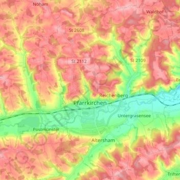
Nom : Carte topographique Pfarrkirchen, altitude, relief.
Lieu : Pfarrkirchen, Landkreis Rottal-Inn, Bavaria, 84347, Germany (48.39223 12.89848 48.48486 13.01114)
Altitude moyenne : 429 m
Altitude minimum : 356 m
Altitude maximum : 483 m
Autres cartes topographiques
Cliquez sur une carte pour visualiser sa topographie, son altitude et son relief.
Walking
Germany > Bavaria > Landkreis Rottal-Inn > Wittibreut
Walking, Wittibreut, Landkreis Rottal-Inn, Bavaria, 84384, Germany
Altitude moyenne : 504 m
Putting
Germany > Bavaria > Landkreis Rottal-Inn > Wurmannsquick
Putting, Wurmannsquick, Landkreis Rottal-Inn, Bavaria, 84329, Germany
Altitude moyenne : 464 m
Hintergrindering
Germany > Bavaria > Landkreis Rottal-Inn > Seemannshausen
Hintergrindering, Seemannshausen, Gangkofen, Landkreis Rottal-Inn, Bavaria, 84140, Germany
Altitude moyenne : 468 m
Gindering
Germany > Bavaria > Landkreis Rottal-Inn > Gangkofen
Gindering, Gangkofen, Landkreis Rottal-Inn, Bavaria, 84140, Germany
Altitude moyenne : 465 m
Gangkofen
Germany > Bavaria > Landkreis Rottal-Inn
Gangkofen, Landkreis Rottal-Inn, Bavaria, 84140, Germany
Altitude moyenne : 471 m
Simbach
Germany > Bavaria > Landkreis Rottal-Inn
Simbach, Landkreis Rottal-Inn, Bavaria, 84359, Germany
Altitude moyenne : 425 m