
Faire un don
Équipez-vous pour votre prochaine aventure :
En tant que Partenaire Amazon, ce site perçoit une commission sur les achats éligibles sans surcoût pour vous.
Carte topographique Bell Island
Cliquez sur la carte pour afficher l’altitude.
Faire un don
Équipez-vous pour votre prochaine aventure :
En tant que Partenaire Amazon, ce site perçoit une commission sur les achats éligibles sans surcoût pour vous.
Bell Island
The coast is very rocky and consists almost entirely of steep cliffs tens of meters high that tower up to 45 kilometres (28 mi) above sea level. The island, which continues to gain in altitude especially close to the coastline, reaches a maximum height of 148 metres (486 ft). Because the central part of the island is relatively flat compared to the coast, seen from the sea it has a somewhat table mountain-like view. Since the island is so high above sea level, on a clear day there are excellent views of the Newfoundland mainland from either side. The cliffs are home to several sea caves and natural bridges and in several places overlook large rocks and sea stacks. Known are The Bell, Coadys Island and The Clapper, all on the southwest coast. There is also a ravine on the east coast that is known as The Scrape. The Front and Lance Cove are almost the only places where the coast is less steep and where you can land from the sea. To the north are Redmans Head and Eastern Head, two prominent capes between which a lighthouse has been built.
Faire un don
Équipez-vous pour votre prochaine aventure :
En tant que Partenaire Amazon, ce site perçoit une commission sur les achats éligibles sans surcoût pour vous.
À propos de cette carte
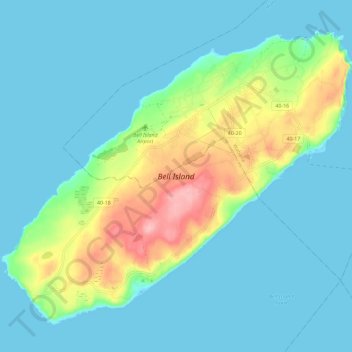
Nom : Carte topographique Bell Island, altitude, relief.
Altitude moyenne : 30 m
Altitude minimum : -1 m
Altitude maximum : 141 m
Faire un don
Équipez-vous pour votre prochaine aventure :
En tant que Partenaire Amazon, ce site perçoit une commission sur les achats éligibles sans surcoût pour vous.