
Carte topographique Edmonton
Carte interactive
Cliquez sur la carte pour afficher l’altitude.
À propos de cette carte
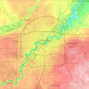
Nom : Carte topographique Edmonton, altitude, relief.
Lieu : Edmonton, Division No. 11, Alberta, Canada (53.33726 -113.71384 53.71626 -113.27148)
Altitude moyenne : 690 m
Altitude minimum : 600 m
Altitude maximum : 783 m
Edmonton is on the North Saskatchewan River, at an elevation of 671 m (2,201 ft). It is North America's northernmost city with a metropolitan population over one million. It is at the same latitude as Hamburg (Germany); Dublin (Ireland); Manchester (United Kingdom); and Magnitogorsk (Russia). It is south of Alberta's geographic centre, which is near the Hamlet of Fort Assiniboine. The terrain in and around Edmonton is generally flat to gently rolling, with ravines and deep river valleys, such as the North Saskatchewan River valley. The Canadian Rockies are west of Edmonton and about 220 km (140 mi) to the southwest.
Autres cartes topographiques
Cliquez sur une carte pour visualiser sa topographie, son altitude et son relief.
Gorman
Canada > Alberta > Division No. 11 > Edmonton
Gorman, Pilot Sound, Edmonton, Division No. 11, Alberta, Canada
Altitude moyenne : 657 m
City of Spruce Grove
Canada > Alberta > Division No. 11
City of Spruce Grove, Division No. 11, Alberta, Canada
Altitude moyenne : 699 m
Athlone
Canada > Alberta > Division No. 11 > Edmonton
Athlone, Northern Mature Area, Edmonton, Division No. 11, Alberta, Canada
Altitude moyenne : 678 m
Argyll
Canada > Alberta > Division No. 11
Argyll, Mill Creek South, Division No. 11, Alberta, Canada
Altitude moyenne : 674 m