
Faire un don
Équipez-vous pour votre prochaine aventure :
En tant que Partenaire Amazon, ce site perçoit une commission sur les achats éligibles sans surcoût pour vous.
Carte topographique Kearney
Cliquez sur la carte pour afficher l’altitude.
Faire un don
Équipez-vous pour votre prochaine aventure :
En tant que Partenaire Amazon, ce site perçoit une commission sur les achats éligibles sans surcoût pour vous.
À propos de cette carte
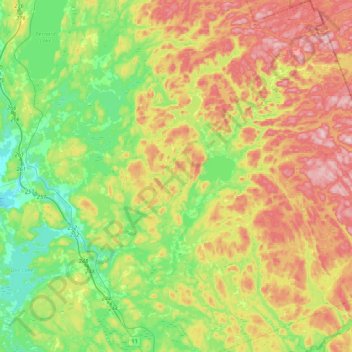
Nom : Carte topographique Kearney, altitude, relief.
Altitude moyenne : 388 m
Altitude minimum : 281 m
Altitude maximum : 542 m
Faire un don
Équipez-vous pour votre prochaine aventure :
En tant que Partenaire Amazon, ce site perçoit une commission sur les achats éligibles sans surcoût pour vous.
Autres cartes topographiques
Cliquez sur une carte pour visualiser sa topographie, son altitude et son relief.
Stormy Lake
Canada > Ontario > Parry Sound District > Unorganized Centre Parry Sound
Altitude moyenne : 227 m
Whistler Bay
Canada > Ontario > Parry Sound District > Unorganized Centre Parry Sound
Altitude moyenne : 178 m
Faire un don
Équipez-vous pour votre prochaine aventure :
En tant que Partenaire Amazon, ce site perçoit une commission sur les achats éligibles sans surcoût pour vous.
Oastler Lake Provincial Park
Canada > Ontario > Parry Sound District > Seguin Township
Altitude moyenne : 218 m
Moon River
Canada > Ontario > Parry Sound District > The Archipelago Township
Altitude moyenne : 185 m
Faire un don
Équipez-vous pour votre prochaine aventure :
En tant que Partenaire Amazon, ce site perçoit une commission sur les achats éligibles sans surcoût pour vous.
Pickerel River
Canada > Ontario > Parry Sound District > Unorganized Centre Parry Sound
Altitude moyenne : 200 m
Dokis Island
Canada > Ontario > Parry Sound District > Unorganized Centre Parry Sound
Altitude moyenne : 196 m
Port Loring
Canada > Ontario > Parry Sound District > Unorganized Centre Parry Sound
Altitude moyenne : 227 m
Restoule
Canada > Ontario > Parry Sound District > Unorganized Centre Parry Sound
Altitude moyenne : 237 m
Faire un don
Équipez-vous pour votre prochaine aventure :
En tant que Partenaire Amazon, ce site perçoit une commission sur les achats éligibles sans surcoût pour vous.
Pointe au Baril
Canada > Ontario > Parry Sound District > The Archipelago Township
Altitude moyenne : 177 m
Dollars Lake
Canada > Ontario > Parry Sound District > Unorganized Centre Parry Sound
Altitude moyenne : 215 m
Faire un don
Équipez-vous pour votre prochaine aventure :
En tant que Partenaire Amazon, ce site perçoit une commission sur les achats éligibles sans surcoût pour vous.
Diamond Lake
Canada > Ontario > Parry Sound District > Seguin Township > Orrville
Altitude moyenne : 273 m
Faire un don
Équipez-vous pour votre prochaine aventure :
En tant que Partenaire Amazon, ce site perçoit une commission sur les achats éligibles sans surcoût pour vous.
Lake Bernard
Canada > Ontario > Parry Sound District > Strong Township > Sundridge
Altitude moyenne : 347 m
Faire un don
Équipez-vous pour votre prochaine aventure :
En tant que Partenaire Amazon, ce site perçoit une commission sur les achats éligibles sans surcoût pour vous.
Arnstein
Canada > Ontario > Parry Sound District > Unorganized Centre Parry Sound
Altitude moyenne : 233 m
Faire un don
Équipez-vous pour votre prochaine aventure :
En tant que Partenaire Amazon, ce site perçoit une commission sur les achats éligibles sans surcoût pour vous.
Ferguson Island
Canada > Ontario > Parry Sound District > Unorganized Centre Parry Sound
Altitude moyenne : 206 m
Manitouwabing Lake
Canada > Ontario > Parry Sound District > McKellar Township > McKellar
Altitude moyenne : 249 m
Faire un don
Équipez-vous pour votre prochaine aventure :
En tant que Partenaire Amazon, ce site perçoit une commission sur les achats éligibles sans surcoût pour vous.
Magnetawan River
Canada > Ontario > Parry Sound District > Unorganized Centre Parry Sound
Altitude moyenne : 198 m
Faire un don
Équipez-vous pour votre prochaine aventure :
En tant que Partenaire Amazon, ce site perçoit une commission sur les achats éligibles sans surcoût pour vous.
Cole Lake
Canada > Ontario > Parry Sound District > Unorganized Centre Parry Sound
Altitude moyenne : 216 m
Conger Lake
Canada > Ontario > Parry Sound District > The Archipelago Township
Altitude moyenne : 200 m
Faire un don
Équipez-vous pour votre prochaine aventure :
En tant que Partenaire Amazon, ce site perçoit une commission sur les achats éligibles sans surcoût pour vous.
Deer Horn Island
Canada > Ontario > Parry Sound District > The Archipelago Township
Altitude moyenne : 199 m
Richardson Island
Canada > Ontario > Parry Sound District > Nipissing Township
Altitude moyenne : 194 m
Key River
Canada > Ontario > Parry Sound District > Unorganized Centre Parry Sound
Altitude moyenne : 194 m
Faire un don
Équipez-vous pour votre prochaine aventure :
En tant que Partenaire Amazon, ce site perçoit une commission sur les achats éligibles sans surcoût pour vous.
Bosworth Island
Canada > Ontario > Parry Sound District > Unorganized Centre Parry Sound
Altitude moyenne : 224 m
Doe Lake
Canada > Ontario > Parry Sound District > McMurrich/Monteith Township
Altitude moyenne : 303 m
Faire un don
Équipez-vous pour votre prochaine aventure :
En tant que Partenaire Amazon, ce site perçoit une commission sur les achats éligibles sans surcoût pour vous.
Culin Lake
Canada > Ontario > Parry Sound District > Unorganized Centre Parry Sound > Arnstein
Altitude moyenne : 230 m
Bob's Lake
Canada > Ontario > Parry Sound District > Unorganized Centre Parry Sound
Altitude moyenne : 255 m
Faire un don
Équipez-vous pour votre prochaine aventure :
En tant que Partenaire Amazon, ce site perçoit une commission sur les achats éligibles sans surcoût pour vous.
Memesagamesing Lake Dam
Canada > Ontario > Parry Sound District > Unorganized Centre Parry Sound
Altitude moyenne : 227 m
Faire un don
Équipez-vous pour votre prochaine aventure :
En tant que Partenaire Amazon, ce site perçoit une commission sur les achats éligibles sans surcoût pour vous.
Dollars Lake
Canada > Ontario > Parry Sound District > Unorganized Centre Parry Sound
Altitude moyenne : 215 m
Jack's Ridge
Canada > Ontario > Parry Sound District > Unorganized Centre Parry Sound
Altitude moyenne : 254 m
Skye Island
Canada > Ontario > Parry Sound District > The Archipelago Township
Altitude moyenne : 191 m
Faire un don
Équipez-vous pour votre prochaine aventure :
En tant que Partenaire Amazon, ce site perçoit une commission sur les achats éligibles sans surcoût pour vous.
Magee Island
Canada > Ontario > Parry Sound District > Unorganized Centre Parry Sound
Altitude moyenne : 196 m
Faire un don
Équipez-vous pour votre prochaine aventure :
En tant que Partenaire Amazon, ce site perçoit une commission sur les achats éligibles sans surcoût pour vous.
Sprucedale
Canada > Ontario > Parry Sound District > McMurrich/Monteith Township
Altitude moyenne : 330 m
Jack's Ridge
Canada > Ontario > Parry Sound District > Unorganized Centre Parry Sound
Altitude moyenne : 254 m
Faire un don
Équipez-vous pour votre prochaine aventure :
En tant que Partenaire Amazon, ce site perçoit une commission sur les achats éligibles sans surcoût pour vous.
Key River
Canada > Ontario > Parry Sound District > Unorganized Centre Parry Sound
Altitude moyenne : 193 m
Smith Bay
Canada > Ontario > Parry Sound District > Unorganized Centre Parry Sound
Altitude moyenne : 217 m
Faire un don
Équipez-vous pour votre prochaine aventure :
En tant que Partenaire Amazon, ce site perçoit une commission sur les achats éligibles sans surcoût pour vous.
Sundridge
Canada > Ontario > Parry Sound District > Strong Township > Sundridge
Altitude moyenne : 355 m
Moon River
Canada > Ontario > Parry Sound District > The Archipelago Township
Altitude moyenne : 185 m
Faire un don
Équipez-vous pour votre prochaine aventure :
En tant que Partenaire Amazon, ce site perçoit une commission sur les achats éligibles sans surcoût pour vous.
Watt Island
Canada > Ontario > Parry Sound District > The Archipelago Township
Altitude moyenne : 195 m
Nipissing
Canada > Ontario > Parry Sound District > Nipissing Township > Nipissing
Altitude moyenne : 227 m
Faire un don
Équipez-vous pour votre prochaine aventure :
En tant que Partenaire Amazon, ce site perçoit une commission sur les achats éligibles sans surcoût pour vous.
Recollet Falls
Canada > Ontario > Parry Sound District > Unorganized Centre Parry Sound
Altitude moyenne : 206 m
Faire un don
Équipez-vous pour votre prochaine aventure :
En tant que Partenaire Amazon, ce site perçoit une commission sur les achats éligibles sans surcoût pour vous.
Orrville
Canada > Ontario > Parry Sound District > Seguin Township > Orrville
Altitude moyenne : 262 m
Loring
Canada > Ontario > Parry Sound District > Unorganized Centre Parry Sound
Altitude moyenne : 241 m
Faire un don
Équipez-vous pour votre prochaine aventure :
En tant que Partenaire Amazon, ce site perçoit une commission sur les achats éligibles sans surcoût pour vous.
Key Harbour
Canada > Ontario > Parry Sound District > Unorganized Centre Parry Sound
Altitude moyenne : 178 m
Clear Lake
Canada > Ontario > Parry Sound District > Unorganized Centre Parry Sound
Altitude moyenne : 222 m
Faire un don
Équipez-vous pour votre prochaine aventure :
En tant que Partenaire Amazon, ce site perçoit une commission sur les achats éligibles sans surcoût pour vous.
Jack's Ridge
Canada > Ontario > Parry Sound District > Unorganized Centre Parry Sound
Altitude moyenne : 254 m