
Carte topographique Ono Island
Carte interactive
Cliquez sur la carte pour afficher l’altitude.
À propos de cette carte
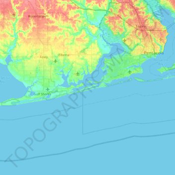
Nom : Carte topographique Ono Island, altitude, relief.
Lieu : Ono Island, Baldwin County, Alabama, United States (29.97353 -87.81748 30.61353 -87.17748)
Altitude moyenne : 9 m
Altitude minimum : -4 m
Altitude maximum : 55 m
Ono Island was along the boundary of the treaties between France and Spain. In 1813, after protests and attempts at rebellion, President James Monroe seized Spanish lands west of the Perdido River and declared them a part of the Louisiana Purchase of 1803. This set the east end of the Island, Perdido Key, at the mouth of the Perdido River, as the boundary between the United States and Spain. That same boundary would later mark the boundary between Alabama and Florida. Ono Island has previously been known as "Goat Island" or "George Kee's Island". George Kee, a caretaker for land belonging to Fred Scott. Scott was an early developer in the Perdido Key area and acquired Ono Island (alongside Innerarity point and other land) via Spanish land grants in the 1820s. Scott brought in goats and allowed them to roam free until there were an estimated 2,000 goats on the island, plus the wild hogs that Kee allowed anyone to shoot for food. At that time, the island was uninhabited except a small house Kee occupied that he built himself. A hurricane in 1916 changed the topography of the island by closing the Key and creating a new opening on the western end of the island. When Florida attempted to claim the land between the old pass and the new, Alabama legislators replied "Oh no you don't." That gave rise to the name, Ono Island.
Autres cartes topographiques
Cliquez sur une carte pour visualiser sa topographie, son altitude et son relief.
Fairhope
United States > Alabama > Baldwin County > Fairhope
Fairhope, Baldwin County, Alabama, United States
Altitude moyenne : 35 m
Foley
United States > Alabama > Baldwin County
Foley, Baldwin County, Alabama, United States
Altitude moyenne : 20 m
Daphne
United States > Alabama > Baldwin County
Daphne, Baldwin County, Alabama, 36526, United States
Altitude moyenne : 25 m
Robertsdale
United States > Alabama > Baldwin County
Robertsdale, Baldwin County, Alabama, United States
Altitude moyenne : 41 m
Douglasville
United States > Alabama > Baldwin County > Bay Minette
Douglasville, Bay Minette, Baldwin County, Alabama, 36507, United States
Altitude moyenne : 75 m
Montrose
United States > Alabama > Baldwin County > Fairhope
Montrose, Fairhope, Baldwin County, Alabama, 36559, United States
Altitude moyenne : 17 m
Orange Beach
United States > Alabama > Baldwin County
Orange Beach, Baldwin County, Alabama, United States
Altitude moyenne : 5 m
Point Clear
United States > Alabama > Baldwin County
Point Clear, Baldwin County, Alabama, 36564, United States
Altitude moyenne : 10 m
Gulf Shores
United States > Alabama > Baldwin County
Gulf Shores, Baldwin County, Alabama, 36542, United States
Altitude moyenne : 5 m
Stockton
United States > Alabama > Baldwin County
Stockton, Baldwin County, Alabama, United States
Altitude moyenne : 20 m
Park City
United States > Alabama > Baldwin County > Daphne
Park City, Daphne, Baldwin County, Alabama, 36526, United States
Altitude moyenne : 17 m
Bay Minette
United States > Alabama > Baldwin County
Bay Minette, Baldwin County, Alabama, 36507, United States
Altitude moyenne : 72 m
Gulf Shores
United States > Alabama > Baldwin County
Gulf Shores, Baldwin County, Alabama, 36542, United States
Altitude moyenne : 4 m
Loxley
United States > Alabama > Baldwin County
Loxley, Baldwin County, Alabama, 36551, United States
Altitude moyenne : 46 m
Fairhope
United States > Alabama > Baldwin County
Fairhope, Baldwin County, Alabama, 36533, United States
Altitude moyenne : 17 m
Perdido Bay
United States > Alabama > Baldwin County
Perdido Bay, Baldwin County, Alabama, United States
Altitude moyenne : 0 m
Perdido River
United States > Alabama > Baldwin County
Perdido River, Baldwin County, Alabama, 35507, United States
Altitude moyenne : 43 m
Spanish Fort
United States > Alabama > Baldwin County
Spanish Fort, Baldwin County, Alabama, United States
Altitude moyenne : 21 m
Summerdale
United States > Alabama > Baldwin County > Summerdale
Summerdale, Baldwin County, Alabama, United States
Altitude moyenne : 34 m
Bay Minette
United States > Alabama > Baldwin County > Bay Minette
Bay Minette, Baldwin County, Alabama, 36507, United States
Altitude moyenne : 72 m
Fairhope
United States > Alabama > Baldwin County > Fairhope
Fairhope, Baldwin County, Alabama, United States
Altitude moyenne : 35 m
Caswell
United States > Alabama > Baldwin County > Orange Beach > Caswell
Caswell, Orange Beach, Baldwin County, Alabama, 36561, United States
Altitude moyenne : 3 m
Lillian
United States > Alabama > Baldwin County
Lillian, Baldwin County, Alabama, 46549, United States
Altitude moyenne : 8 m