Géolocaliser

Carte topographique Anchalummood

Cliquez sur la carte pour afficher l’altitude.

À propos de cette carte

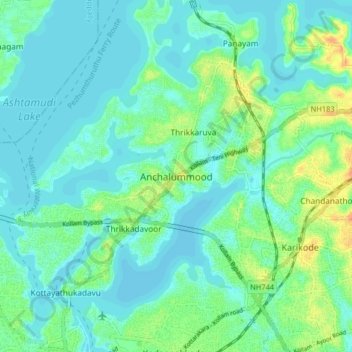
Nom : Carte topographique Anchalummood, altitude, relief.

Lieu : Anchalummood, Kollam, Kerala, 691601, India (8.89243 76.56411 8.97243 76.64411)

Altitude moyenne : 10 m

Altitude minimum : 1 m

Altitude maximum : 36 m

Autres cartes topographiques

Cliquez sur une carte pour visualiser sa topographie, son altitude et son relief.

Kollam

India > Kerala > Kollam > Eravipuram

Altitude moyenne : 9 m

Pozhikara Temple Pond

India > Kerala > Kollam > Paravur

Altitude moyenne : 5 m

Ashtamudi Lake

India > Kerala > Kollam > Kottayathukadavu

Ashtamudi Lake (Ashtamudi Kayal), in the Kollam District of the Indian state of Kerala, is the most visited backwater and lake in the state. It possesses a unique wetland ecosystem and a large palm-shaped (also described as octopus-shaped) water body, second only in size to the Vembanad estuary ecosystem of…

Altitude moyenne : 6 m

Mukhathala Kulam

India > Kerala > Kollam > Thrikkovilvattom

Altitude moyenne : 18 m

Ithikkara

India > Kerala > Kollam > Nellettil

Altitude moyenne : 35 m

Kundara

India > Kerala > Kollam > Kundara

Altitude moyenne : 32 m

Équipez-vous pour votre prochaine aventure :

🧭Boussoles d’orientation - Boussoles fiables pour navigation terrestre et lecture de cartes
🧥Veste coupe-vent - Protection légère contre les courants d'air sur les crêtes
🔌Chargeurs solaires - Autonomie énergétique
🔥Réchauds de camping - Réchauds compacts pour cuisine outdoor
🧪Pastilles de purification - Rendez l'eau potable en toutes circonstances lors de vos expéditions

En tant que Partenaire Amazon, ce site perçoit une commission sur les achats éligibles sans surcoût pour vous.