
Carte topographique Kirchehrenbach
Carte interactive
Cliquez sur la carte pour afficher l’altitude.
À propos de cette carte
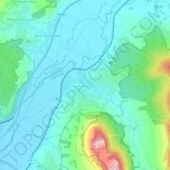
Nom : Carte topographique Kirchehrenbach, altitude, relief.
Altitude moyenne : 320 m
Altitude minimum : 271 m
Altitude maximum : 516 m
Autres cartes topographiques
Cliquez sur une carte pour visualiser sa topographie, son altitude et son relief.
Forchheim
Deutschland > Bayern > Landkreis Forchheim
Forchheim, Landkreis Forchheim, Bayern, 91301, Deutschland
Altitude moyenne : 299 m
St. Walpurgis
Deutschland > Bayern > Landkreis Forchheim > Kirchehrenbach
St. Walpurgis, Kirchehrenbach, Kirchehrenbach (VGem), Landkreis Forchheim, Bayern, 91356, Deutschland
Altitude moyenne : 347 m
Hallerndorf
Deutschland > Bayern > Landkreis Forchheim
Hallerndorf, Landkreis Forchheim, Bayern, 91352, Deutschland
Altitude moyenne : 295 m