
Carte topographique Central District
Carte interactive
Cliquez sur la carte pour afficher l’altitude.
À propos de cette carte
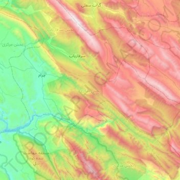
Nom : Carte topographique Central District, altitude, relief.
Altitude moyenne : 1’721 m
Altitude minimum : 544 m
Altitude maximum : 3’480 m
Autres cartes topographiques
Cliquez sur une carte pour visualiser sa topographie, son altitude et son relief.
Bi Bi Hakimeh
Iran > Kohgiluye and Buyer Ahmad Province > Gachsaran County > دهستان بی بی حکیمه
Bi Bi Hakimeh, دهستان بی بی حکیمه, بخش مرکزی, Gachsaran County, Kohgiluye and Buyer Ahmad Province, Iran
Altitude moyenne : 437 m
Boyer Ahmad
Iran > Kohgiluye and Buyer Ahmad Province > Buyerahmad County > Yasuj
Boyer Ahmad, ناحیه ۱, Yasuj, بخش مرکزی بویراحمد, Buyerahmad County, Kohgiluye and Buyer Ahmad Province, Iran
Altitude moyenne : 1’845 m
Yasuj
Iran > Kohgiluye and Buyer Ahmad Province > Buyerahmad County
Yasuj, بخش مرکزی بویراحمد, Buyerahmad County, Kohgiluye and Buyer Ahmad Province, 75917-78449, Iran
Altitude moyenne : 1’860 m
Abadeh
Iran > Kohgiluye and Buyer Ahmad Province > Buyerahmad County > دهستان لوداب
Abadeh, دهستان لوداب, بخش لوداب, Buyerahmad County, Kohgiluye and Buyer Ahmad Province, Iran
Altitude moyenne : 1’548 m
Yasuj
Iran > Kohgiluye and Buyer Ahmad Province > Buyerahmad County > Yasuj
Yasuj, بخش مرکزی شهرستان بویراحمد, Buyerahmad County, Kohgiluye and Buyer Ahmad Province, 7591778449, Iran
Altitude moyenne : 2’335 m
Dogonbadan
Iran > Kohgiluye and Buyer Ahmad Province > Gachsaran County > دهستان لیشتر
Dogonbadan, دهستان لیشتر, بخش مرکزی, Gachsaran County, Kohgiluye and Buyer Ahmad Province, Iran
Altitude moyenne : 774 m
Dena
Iran > Kohgiluye and Buyer Ahmad Province > Dena County > دهستان دنا
Dena, دهستان دنا, بخش مرکزی دنا, Dena County, Kohgiluye and Buyer Ahmad Province, Iran
Altitude moyenne : 3’896 m